

Egypt
Gilf Kebir National Park
Gilf Kebir National Park
Location
Gilf Kebir National Park
23.5000° / 26.0000°


Experience Gilf Kebir National Park, Your Way
Skip the standard itineraries. We'll design a journey around your interests, timeline, and travel style — with exclusive access you won't find elsewhere.

Things to Do in Gilf Kebir National Park
Starting points for your perfect trip
Cave of Swimmers Expedition
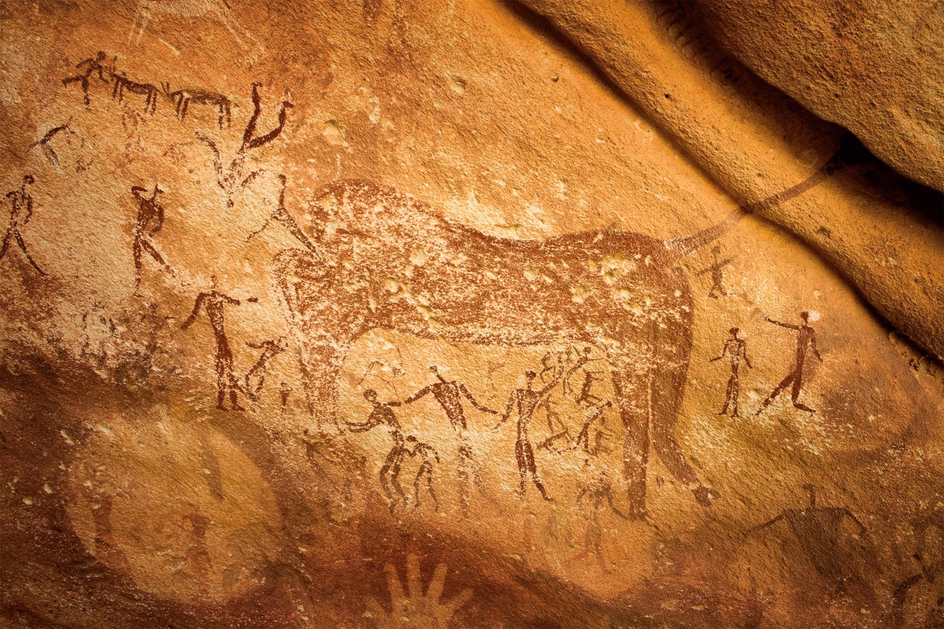
Visit Wadi Sura’s 8,000-year-old rock art discovered in 1933, with “swimming” human figures revealing a once-green Sahara of rivers and lakes.
Libyan Desert Glass Field
Search the sand north of the Gilf plateau for translucent yellow-green glass fragments formed by a meteorite or airburst event 29 million years ago. One piece of this cosmic silica was carved into a scarab and set into King Tutankhamun’s burial pectoral, now in the Egyptian Museum.
Cave of Beasts Discovery
Reach Wadi Sura II, found in 2002 by Massimo and Jacopo Foggini and Ahmed Mestikawi just 10 kilometers from Almásy’s original site. Nearly 5,000 painted figures include headless ‘beasts’ surrounded by floating human forms and scenes of dancing, hunting, and ritual.

Jebel Uweinat Rock Art
Explore the 1,934-meter granite massif at the tripoint of Egypt, Sudan, and Libya, with over 750 documented rock art sites in Karkur Talh valley. Paintings spanning 6,000 years depict cattle, giraffes, ostriches, and scenes of pastoral life during the Sahara’s green period.

Wadi Hamra Red Valley Traverse
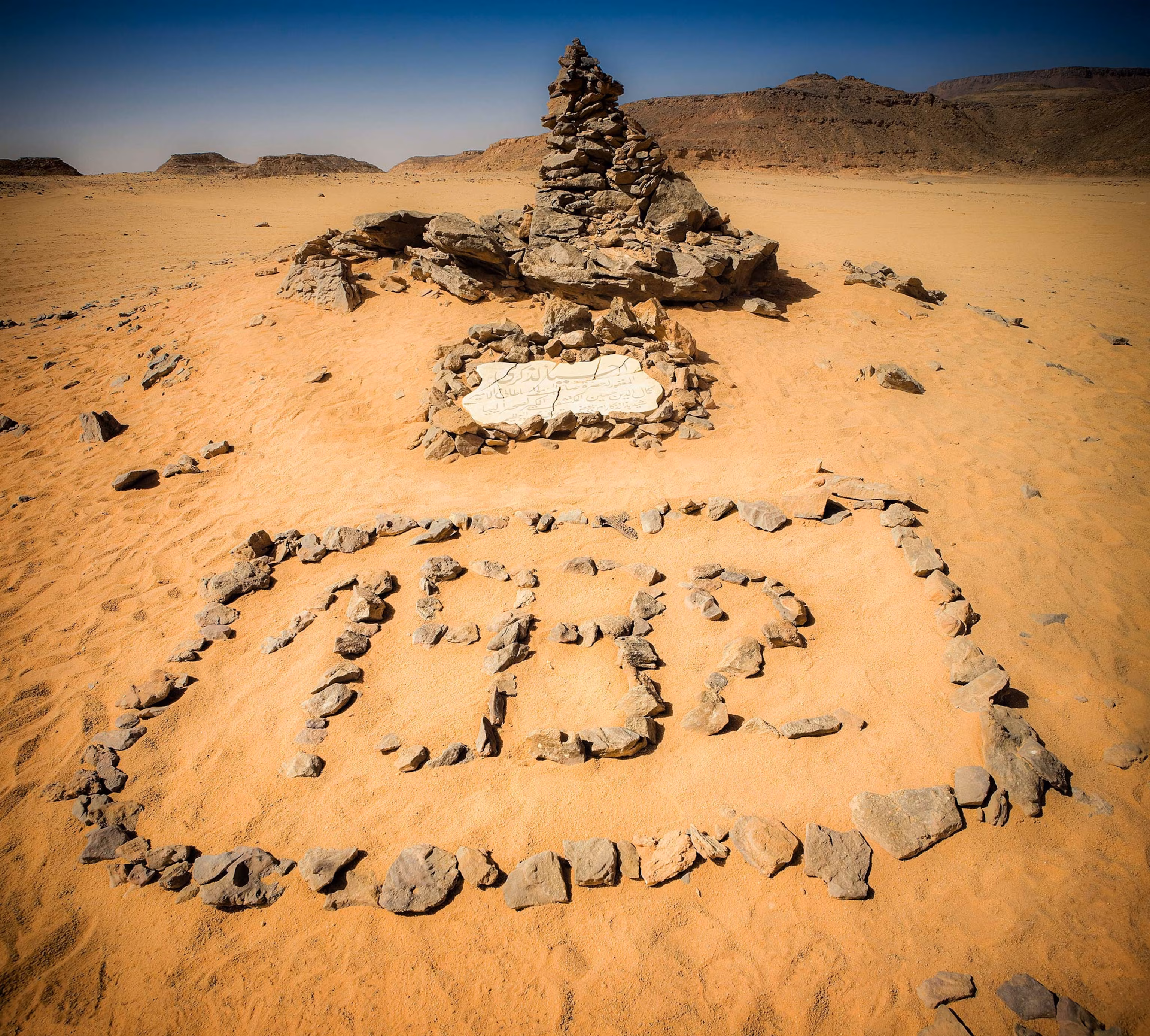
Drive into the Gilf’s most accessible wadi, where rust-red sand dunes sit against black sandstone cliffs. Prince Kamal el Din Hussein first entered this valley in 1926 during his mapping expeditions. Acacia trees cling to the wadi floor and Barbary sheep tracks mark the escarpment ledges.

Eight Bells WWII Airfield
Visit the Long Range Desert Group’s Eight Bells airstrip, where jerry can runway markers still mark the sand 80 years later, echoing WWII desert missions and covert crossings.

Stories from Gilf Kebir National Park
The Driest Place on Earth
Gilf Kebir defies comprehension. Established as a national park in 2007, this 48,533-square-kilometer protected area covers roughly 5% of Egypt’s entire territory and encompasses three distinct ecosystems: the southern reaches of the Great Sand Sea with its silica glass field formed by a meteorite 29 million years ago, the sandstone plateau of the Gilf Kebir proper rising 300 meters from the desert floor across 7,770 square kilometers, and Egypt’s portion of the 1,934-meter Jebel Uweinat massif at the tripoint with Sudan and Libya. Together they form one of Earth’s most extreme and least-visited landscapes, accessible only by multi-week 4×4 expedition from Dakhla Oasis, 350 kilometers to the northeast.
Statistics barely capture the reality. Annual rainfall averages less than 0.1 millimeters, and rain may fall only once every twenty years. The geological aridity index exceeds 200, meaning solar energy evaporates 200 times any precipitation received. Temperature swings of 30°C between day and night are common, ranging from below freezing before dawn to over 40°C by midday. NASA has studied this region as an analog for Mars. Yet within this apparent desolation, life persists: endangered Barbary sheep navigate the rocky escarpments, desert-adapted acacia trees cling to wadi floors where ancient water channels once ran, and human history stretching back eight millennia is painted on canyon walls.
Stories from Gilf Kebir National Park
 Destinations
Egypt’s Gilf Kebir: A Complete Travel Guide
Neolithic swimmers, cosmic glass, a lost oasis, and a World War II airstrip made of petrol cans. Egypt's last true wilderness is not just remote. It's another planet.
Read Full StoryGetting to Gilf Kebir National Park
Full Expedition from Dakhla Oasis
Extended Route via Bahariya
Jebel Uweinat Extension
Travel with EcoVoyager
Gilf Kebir lies 350 kilometers from the nearest settlement at Dakhla Oasis across roadless desert, requiring a convoy of three 4x4 vehicles, military permits, liaison officers, satellite communication, and complete self-sufficiency for water, fuel, and supplies. EcoVoyager works with Egypt’s most experienced desert operators based in Dakhla and Bahariya, who have run Gilf expeditions since the 1990s, securing permits that require 3–6 months of military coordination, arranging drivers who know the unmarked routes, and provisioning the 10–18-day journeys that reach the Cave of Swimmers, Cave of Beasts, Libyan Desert Glass field, and Jebel Uweinat’s 750 rock art sites.

Explore More
Other Egypt Destinations

Red Sea Liveaboards
Jacques Cousteau rediscovered the SS Thistlegorm in 1955, but it was not until the 1990s dive tourism boom that the...
Explore
Hurghada
Founded as a fishing settlement in 1905 along a harbor where the ‘Ababda, Rashaida, and Ma’aza Bedouin tribes gathered, Hurghada...
Explore
Sharm El Sheikh
Ras Mohammed became Egypt’s first protected marine reserve in 1983 to safeguard coral ecosystems where the Gulf of Suez meets...
Explore
Dahab
Dahab, Arabic for gold, takes its name from the golden sands where the Sinai Desert meets the Gulf of Aqaba....
Explore
Alexandria
Alexander the Great founded this city in 331 BC on a strategic peninsula where the Nile Delta meets the Mediterranean,...
Explore
Aswan
Where the Nile flows at its most beautiful, Aswan marks Egypt's historic frontier—the ancient border between pharaonic Egypt and the...
Explore
Marsa Alam
Where the Eastern Desert meets the Red Sea, 274 kilometers south of Hurghada, lies Egypt's most pristine diving frontier. Marsa...
Explore
Siwa Oasis
In Egypt's Western Desert, 560 kilometers from Cairo, Siwa Oasis rises from a depression 19 meters below sea level—a palm-fringed...
Explore
White Desert National Park
In Egypt's Western Desert, 500 kilometers southwest of Cairo, the White Desert National Park preserves one of Earth's most surreal...
Explore
Abu Simbel
On Lake Nasser's western bank, 20 kilometers from the Sudanese border, four colossal statues of Ramesses II have guarded Egypt's...
Explore
Luxor
Ancient Thebes served as Egypt's capital during the Middle and New Kingdoms, an era spanning fifteen centuries when pharaohs built...
Explore
Giza
On a limestone plateau overlooking the Nile, the Pyramids of Giza have stood for 4,500 years as the only surviving...
Explore
Cairo
Founded in 969 CE by the Fatimid dynasty, Cairo stands as one of the world's oldest Islamic cities and a...
ExploreSwipe to explore more