Bolivia
A 16-day private expedition across Bolivia, from the dinosaur canyons of Toro Toro to the salt flats and volcanoes of the deep Altiplano
Ecovoyager Experiences
The moments that make this journey unforgettable.

Bolivia Tour Overview
A 16-day private expedition across Bolivia, from the dinosaur canyons of Toro Toro to the salt flats and volcanoes of the deep Altiplano
This 16-day expedition crosses Bolivia from its dinosaur-tracked highlands in the east to the volcanic silence of Sajama in the west. The route moves through Toro Toro National Park (dinosaur footprints, Bolivia’s largest cave system, Andean Condor territory), colonial Sucre, the blood-red canyon country of Tupiza, and into the deep Altiplano: Laguna Colorada, the Dalí Desert, Sol de Mañana geysers, and the Salar de Uyuni, and finally into the remote volcanic landscapes of Sajama National Park. Every transfer runs in a private 4×4, and every overnight is chosen for its place in the landscape and the community around it.
The Great Andean Altiplano Expedition
Your expedition begins in Santa Cruz. Our driver transfers you to Viru Viru International Airport for the short domestic flight to Cochabamba, Bolivia's gastronomical capital. On arrival at Jorge Wilstermann Airport, our driver meets you for the transfer to Hotel Aranjuez. Sitting at a comfortable 2,550m, Cochabamba offers a gentle introduction to altitude before the higher terrain to come. This evening we gather for a welcome dinner at one of Cochabamba's finest local restaurants, the first taste of Bolivian cuisine and the official start of the expedition.
Flight: Santa Cruz (VVI) → Cochabamba (CBB), included
Meals D
Leaving Cochabamba early, we cross the magnificent Río Caine valley, the natural border between the departments of Cochabamba and Potosí, arriving in the colonial village of Torotoro (2,700m) for lunch. In the afternoon we descend into Torotoro Canyon, following the trail to El Vergel: a hidden waterfall tucked deep within the canyon walls. The hike involves a steep descent and a demanding climb back out, a proper physical challenge rewarded with spectacular scenery and towering canyon views.
Distance: 87 miles / ~3 hours
Meals B / L / D
We set off toward the triangular mountains of Torotoro, donning helmets before entering the Humajalanta caves, home to 5km of galleries hosting extraordinary geological formations and large bat colonies, the largest cave system in Bolivia. After a picnic lunch in the middle of nature, we climb to Ciudad de Itas: a natural city carved from rock with commanding views of the Cordillera. This high-altitude walk requires solid fitness but rewards with some of the most dramatic scenery in Bolivia, with a real chance of spotting the Andean Condor.
Walking time: approx. 5.5 hours
Meals B / L / D
We follow the Rio Caine to Tarata for a walk through the colonial town square to the famous Melgarejo bridge, built by Bolivia's most eccentric dictator so his horse wouldn't get its hooves wet. We continue to Aiquile for lunch, famous across Bolivia for its charangos. A visit to a local charango-maker's workshop may be possible here (not guaranteed, but a welcome bonus if available). The afternoon drive follows the Valle Alto and Rio Grande south to Sucre, Bolivia's constitutional capital, arriving by end of day.
Distance: 249 miles / ~7 hours
Meals B / L
We depart at 08:30 by private 4x4 for Chataquila (3,550m) and its charming chapel, then walk down a pre-Inca stone path to Chaunaca, covering 6km of ancient trail with a descent of 770m. After a countryside picnic, we drive into the Maragua Crater for an afternoon between the crater village and a walk to the Devil's Cave, where a waterfall appears unexpectedly. The return to Sucre stops at the Mirador de Maragua for full crater views and the Mirador de Sucre for a panorama over the white city. Evening: dinner and live regional dance performance at Origénes Cultural Center.
Walking: 3 hours, +70m / -770m
Meals B / L / D (Origénes Cultural Center)
We drive to Candelaria in the heart of Tarabuco country, a Quechua-speaking region renowned for hand-woven textiles of extraordinary intricacy. We share a traditional lunch with a host family using produce grown by the community, visit the small museum in the company of a local weaver, then are invited into her private workshop, a rare opportunity to see techniques passed down for generations. The afternoon closes with a walk in the surrounding landscape, and back in Sucre, cocktails at one of the city's finest rooftop bars with intimate views over the white city at dusk.
Distance: 106 miles / ~4 hours

Meals B / L
A long and visually spectacular drive south. We cross the Cordillera de los Frailes toward the Altiplano and stop in Potosí, once the largest city in the Americas and the engine of Spain's colonial silver wealth, stopping for a city centre visit and lunch before continuing. The landscape shifts dramatically as we push south: desert plains give way to ocher-red valleys as we approach Tupiza in the late afternoon. We close the day at the Palala viewpoint for sundowners as the last light caresses the multicoloured canyon rock formations, one of the most memorable moments of the entire expedition.
Distance: 249 miles / ~7 hours
Meals B / L
A full day of varied exploration. By mountain bike through a green valley to El Angosto and the Mirador de Entre Ríos, where the San Juan del Oro and Tupiza rivers meet in contrasting colors. By 4WD through the Quebrada Seca's cactus-covered red mountains and Canyon Duende, stopping at Toroyoj for tamales. In the afternoon, horseback through the Canyon of Palmira, Puerta del Diablo, Canyon of the Inca, and the Valle de los Machos, a surreal landscape of multi-coloured phallic rock formations. The day closes with an 800m mountain bike descent from El Sillar back to town.
Mountain biking: ~1.5 hours | Horseback riding: ~2 hours
Meals B / L
We leave the paved world behind. Up the Palala Canyon to Sillar's lunar volcanic landscape, past the Cañón del Inca and through the desolate mining territories of Nazarenito, Chilcobija, Trapiche, and San Pablo de Lipez. We pass through San Vicente, where Butch Cassidy and the Sundance Kid met their end in a shootout with the Bolivian army; their bodies were never identified and the legend lives on. We arrive in Guadalupe, a community of just three families, where Marina welcomes us to Hospedaje de la Roma. Accommodation is basic with no hot water, but clean and welcoming.
Terrain: Full offroad | Distance: 62 miles / ~3 hours | Elevation gain: +5,413ft
Note: A lightweight sleeping bag is recommended for comfort at this stop. Blankets are provided but guests should purchase a sleeping bag before travel rather than renting on arrival.
Meals B / L / D
A morning walk around the Ciudad de Roma formation, an extraordinary eroded landscape of monumental rock penitents ranging from white to blood red through every shade of ochre and grey. Your guide identifies the amazingly shaped formations: the cathedral, the crocodile, the condor, the llama. The horizon is dominated by snow-capped volcanoes including the broad Cerro Lípez range (5,930m). We return to Guadalupe and continue by 4WD to Quetena, stopping en route to take in the Laguna Celeste. Route may vary by season; lunch is organised beside a laguna when conditions allow.
Terrain: Remote offroad altiplano | Distance: 50 miles / ~3 hours
Meals B / L / D
We drive west to Laguna Colorada, its intense brick-red hue produced by phytoplankton reacting to sunlight, with flamingos wading at its edges. On to the Sol de Mañana geysers at 4,850m, a volcanic crater emitting sulphur vapors and hot water jets reaching 50 meters. A stop at the Polques thermal baths, then through the Dalí Desert to Laguna Blanca and Laguna Verde at the foot of Licancabur volcano (5,960m), where wind transforms the lake into spectacular emerald green. We return through the Siloli Desert to the famous Stone Tree, where viscachas occasionally venture onto the rocks.
Distance: 168 miles / ~7 hours | Max elevation: 4,850m

Meals B / L / D
North along the Chilean border on the Route of the Jewels, named for the string of extraordinary lagunas along its path: Honda, Ch'arkota, Hedionda, and Cañapa, home to all three species of Andean flamingo. We stop at the viewpoint of Volcano Ollagüe (5,868m), still active and home to one of the world's highest open-pit copper mines. We cross the Salar de Chiguana at the foot of Volcano Tomasamil (5,900m) before arriving at San Pedro de Quemez (3,690m) for the night.
Distance: 106 miles / ~3.5 hours | Elevation change: -2,001ft
Meals B / L / D
Today we drive onto the world's largest salt flat. After two hours on the Salar de Uyuni (3,650m), we reach Incahuasi Island, a volcanic formation adrift in the white expanse, covered with stromatolites and giant cacti with sweeping views of the surrounding volcanoes. We head north toward Tunupa volcano, stopping at the Cave of the Galaxy and the museum at Coquesa, where Chipaya mummies recovered from the slopes of Tunupa are on display. We arrive at Tahua for a stunning sunset over the salar. Optional stargazing can be arranged for this evening on request.
Distance: 106 miles / ~3.5 hours


Meals B / L / D
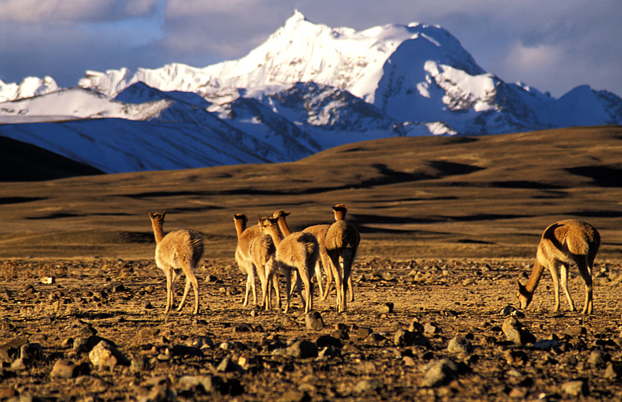
One of the most visually dramatic driving days of the expedition. From Tahua north on asphalt, branching toward the partially dried Lake Poopó, then west into Sajama National Park. We enter on a track leading to the village set between three of Bolivia's most imposing volcanoes: Sajama (6,542m, Bolivia's highest), and the Payachatas twins: Parinacota (6,348m) and Pomerape (6,240m). Large herds of llamas graze here alongside vicuñas and ñandus. We spend the night at Tomarapi Ecolodge.
Optional upgrade: The Intersalar Road extension adds one day between Tahua and Sajama, a fully offroad track along the Chilean border across the Coipasa salt flat, with an overnight in the remote Chipaya village. Contact us for pricing.
Distance: 261 miles / ~8.5 hours | Elevation gain: +1,739ft

Meals B / L / D
A gentle start at the Huaña Khota lagoon, the nesting ground of pink flamingos who share the water with local ducks and wild geese. Before leaving the park, guests may soak in the thermal baths at the foot of Sajama volcano, with a medium trek available for those who want to earn the dip. One last look at the Sajama massif, then the drive to La Paz (estimated arrival 19:00). The expedition closes with a farewell dinner at a traditional La Paz restaurant, a final celebration of two extraordinary weeks.
Distance: 180 miles / ~5 hours | Elevation change: -1,969ft
Meals B / L / D (farewell dinner)
Our driver collects guests from the hotel and transfers them to El Alto Airport for onward flights. End of the Great Andean Altiplano Expedition.
Meals B
Flora & Fauna
Vultur gryphus
The largest flying bird in the world by combined weight and wingspan, riding thermals along the eastern cordillera.
 Vulnerable
Phoenicoparrus andinus
The largest flamingo species in the Andes and one of the rarest flamingo species in the world, distinguished by its unique yellow legs and specialized high-altitude adaptations.
 Least Concern
Vicugna vicugna
The smallest and most graceful of the South American camelids, prized for producing the world's finest natural fiber and considered the national animal of Peru.
Bolivia Tour Details
Everything included in the tour, and what to budget separately.
Bolivia Tour Details
Transparent pricing, comprehensive inclusions, and exactly what to expect.
Per Person
$5,700
Based on double occupancy
| Group Size | Per Person | Notes |
|---|---|---|
| Solo traveler | Price on request | Contact us |
| 2 travelers | $8,100 | Per person |
| 3 travelers | $6,800 | Per person |
| 4 travelers | $5,700 | Per person |
| 5–6 travelers | $5,700 | Per person |
| 7+ travelers | $5,200 | Per person |
Ready to secure your place?
Book This ExpeditionBolivia Adventures
Complete your booking request and our travel specialists will be in touch within 24 hours to confirm your journey.
Thank you. We will be in touch within 24 hours to confirm your place on The Great Andean Altiplano Expedition.
Traveler Stories
"Watching the northern lights from that coastal overlook was one of those moments you carry with you. EcoVoyager's team knew exactly where to take us and when."
"They made my trip to Chile super smooth. I had nothing to worry about, they connected me with local guides and took me to some super cool places."
"My kids are still talking about the lemurs months later. EcoVoyager handled every detail so we could actually be present together."
"Absolutely loved our Mongolia trip in July 2025! Ecovoyager put together the best itinerary possible that combined adventure and comfort. We would 100% recommend Ecovoyager to our friends and family!"
"The Rupununi was fabulous. Even if there weren't any animals, it would've been a great experience. The only negative was leaving."
"The trip was thoughtfully curated for a REAL Cuban cultural experience, juxtaposing between the island's insolvency and the faux luxuries propped up by foreign investment."
"The salt flats at sunrise were even more stunning than I'd imagined. Our guide positioned us perfectly for the reflections."
"EcoVoyager put my mind at ease with expert guidance on how to stay safe and enjoy the vibes. If I were to plan another solo trip to an unfamiliar country, I'd trust EcoVoyager to help me through it all."
"I had a wonderful time. Organization was superb and our experiences were maximized due to great planning and enthusiasm."
"Staying with nomadic families, riding through valleys with no other tourists in sight. This is the kind of travel I didn't know I was missing."
Related Experiences
Explore more expeditions in Bolivia, led by local experts and built for the curious traveller.

Bolivia
A 10-day expedition across Bolivia's volcanic southwest, both great salt flats, and the territory of the Uru-Chipaya, the Andes' oldest people

Bolivia
Two critically endangered macaws and 300 other species across canyon and savanna Bolivia
Bolivia
An 11-day expedition from La Paz through Madidi National Park to the Moseten communities of Pilon Lajas: shoeshine guides, suspended jungle camps above Mashi Lagoon, and three nights with the people who have protected this Amazon for generations
Bolivia
A 25-day expedition from the Amazon basin to the Salar de Uyuni, Lake Titicaca, and the remote Apolobamba range
Bolivia
An 11-day expedition through Amboro National Park, the Gran Chaco, and the UNESCO Jesuit Missions of the Chiquitania

Bolivia
A seven-day descent of the eastern Andes by bike, foot, and river, from La Cumbre to the cloud forest of Coroico
Destination
Each stop on this journey through Bolivia, and the country that ties them together.
Support
Everything you need to know before your journey. Cannot find what you are looking for? Get in touch and we will help.
How this private expedition is priced and scheduled.
It runs in the dry season, May to October, for clear skies, a firm surface on the Salar, open tracks across the altiplano, and the best conditions in the canyons and at the high lakes. Nights are cold at altitude year round. A scheduled October departure is offered, and as a private trip it can also run on your own dates.
The expedition is priced by party size. The rate is $5,700 per person at four to six guests, higher for smaller parties, and lower at seven or more, with solo pricing on request. The full scale is shown on the page.
A deposit of $1,425 per person, twenty-five percent of the rate, secures your place, with the balance due before departure. You can pay by card, bank transfer, or wire.
Yes. It runs privately for your own party, capped at eight guests, with a private 4x4 and driver-guide throughout.
Preparing for a route that climbs into the deep altiplano.
The trip begins lower in Santa Cruz, Cochabamba, and Toro Toro, roughly 2,000 to 3,600 meters, and climbs into the deep altiplano, where Ciudad de Itas, the Sol de Manana geysers, and the high lagoons sit between 4,000 and 4,900 meters. The gradual ascent helps you adjust, but take the high southwest days steady and consult your doctor about altitude medication if you have any heart or respiratory condition.
The earlier days at moderate altitude ease you in. Hydrate well, take the first high days slowly, and rest when you need to. Coca tea is widely available and many travelers find it helps.
The Umajalanta cave involves scrambling, ducking, and some tight passages. It is optional, so if you have mobility concerns or claustrophobia you can skip it and explore above ground instead. Tell your guide either way.
Comprehensive travel insurance is mandatory and must cover high altitude, caving, horse riding, and remote medical evacuation, since the southwest altiplano is a long way from the nearest hospital.
What the active days ask of you.
Moderate. Much of it is private 4x4 touring, but there are active days: caving and canyon stairs at Toro Toro, walking at altitude, and optional riding and biking at Tupiza. Nothing is technical, but reasonable fitness and comfort at altitude make it more enjoyable.
No. The horse riding and mountain biking are options. You can do either, both, or neither and see the red canyon country on foot or by vehicle instead.
There are day walks on uneven ground at altitude, the Toro Toro canyon and caves, the Maragua crater, and various viewpoints, all at a relaxed pace with time to rest.
Some are long. The deep-altiplano legs around Guadalupe, Ciudad de Roma, and Quetena mean several hours on rough tracks in the 4x4, broken by stops. They test your patience for travel more than your fitness.
What to expect across the country's emptier corners.
Every transfer is in a private 4x4 with a driver-guide. The deep-altiplano sections cross remote, largely roadless country, with long distances between stops and very few services along the way.
Very, in the southwest. A couple of nights are in basic accommodation with limited facilities and no hot water, chosen because they are the only option in some spectacular and isolated places.
The cities and towns, Cochabamba, Sucre, Potosi, and Tupiza, have coverage. Toro Toro is limited, and the deep altiplano and Sajama are largely off-grid, so treat those stretches as a disconnection.
Expect bright, dry days with very strong high-altitude sun and cold nights that drop below freezing on the altiplano. You need to pack for both extremes in the same day.
Where you sleep, and what to bring.
It ranges from comfortable hotels in Cochabamba, Sucre, and Tupiza to an ecolodge at Toro Toro, simple refuges and a salt hotel in the southwest altiplano, and the Tomarapi ecolodge at Sajama. The remote stays are basic by necessity; the town stays are comfortable.
Bring warm layers and a windproof for cold nights and high passes, strong sun protection and a hat, sturdy shoes for the caves and canyons, a headlamp, and clothes you do not mind getting dusty on the caving and off-road days. A small daypack is useful for the walks.
In the cities, yes. Across the remote altiplano stretch, plan to be self-sufficient for several days, as services are scarce.


