
The conversation about Guatemala starts and ends in the same two places. Tikal for the ruins. Antigua for the colonial architecture. Every travel blog, every tour operator, every package itinerary. The circuit is so established that most visitors never question it.
What the circuit misses is significant. Guatemala contains 37 volcanoes, the largest Maya city ever built, the biggest cloud forest in Central America, an Afro-Caribbean coast with its own language and culture, a crater lake that closes to outsiders during the most important Maya rain ceremony of the year, and a jungle river where limestone walls rise 150 meters straight out of the water and hot springs bubble directly from the cliff face.
None of it appears on the standard itinerary. All of it is accessible. This guide covers nine locations across Guatemala that reward the travelers willing to look past the obvious.

El Mirador
El Mirador is the largest Maya city ever discovered, and by most measures the most significant archaeological site in the Western Hemisphere. La Danta, its central pyramid, rises 72 meters and surpasses the Great Pyramid of Giza in total volume. The city dates to 600 BCE, predating Tikal by a thousand years, and at its peak held a population of 200,000 people. Over 850 structures have been mapped across the site, connected by raised limestone causeways that stretch for kilometers through the jungle. Most of it remains unexcavated.

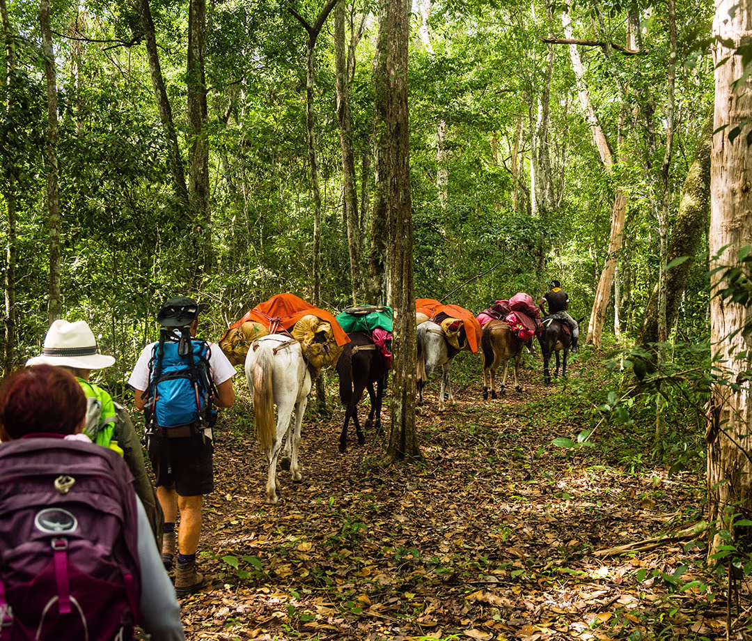
The site sits in the far north of the Petén, 60 kilometers from the nearest road, inside the Maya Biosphere Reserve. Getting there requires a five-day trek through primary rainforest. The trail passes El Tintal on day one, a secondary site with its own pyramid complex that most visitors have never heard of, before reaching El Mirador on day two. The surrounding forest is among the best preserved in Central America, with confirmed populations of jaguar, puma, Baird’s tapir, howler and spider monkeys, and scarlet macaw.
The view from the summit of La Danta at sunrise covers 360 degrees of unbroken canopy. There are no other structures visible. No roads, no cleared land, no signs of the present. Just the jungle and what is buried beneath it.
Yaxhá
Yaxhá translates from Yucatec Maya as “blue-green water,” and the name is accurate. The site sits on the north shore of a jade-colored lagoon in the Yaxhá-Nakum-Naranjo National Park, 70 kilometers east of Flores, and Guatemala’s third-largest Maya city rises from the jungle in stone pyramids and plazas across 400 hectares. Over 500 structures have been documented. Temple 216 stands above the canopy at a height where the full geography becomes visible: the lagoon below, the endless green of the Petén above, and on clear evenings, the last light turning everything amber.

What Yaxhá offers that Tikal does not is quiet. The site draws a fraction of the visitors, the pyramids can be climbed without a queue, and the lagoon is close enough that Morelet’s crocodiles are visible from the shore. A small boat crosses to Topoxté, an island site with Post-Classic architecture that functioned until approximately 1450 CE and receives almost no visitors. Howler monkeys are present throughout the day and audible long before dawn.
Nakum, 18 kilometers north of Yaxhá, reaches further into isolation. Tall pyramids and long causeways remain partially buried, the jungle having reclaimed the architecture over centuries. It is a major city, historically significant, and largely unreached.

Laguna Chicabal
Laguna Chicabal is a crater lake inside an extinct volcano at 2,712 meters, in the Sierra Madre of western Guatemala. It is also the cosmological center of the Mam Maya world, and the distinction matters.
The Mam believe the lake is the home of rain spirits. Ceremonial altars line the shore. Offerings of copal incense, alcohol, candy, and flowers are made to the beings beneath the water. Swimming is forbidden. Fishing is forbidden. Washing is forbidden. These are not rules for tourists. They are the lake’s terms, maintained by the Mam for generations, and they predate any government regulation by centuries.

The hike descends 615 stone steps through cloud forest into the crater. The lake appears through the trees at the bottom, dark and perfectly still on calm mornings, wreathed in mist by mid-morning when cloud rolls in from the Pacific side of the mountains. The forest around the crater holds wine-throated hummingbirds and the specific acoustic quality of places where wind and water are the only sounds.
Every year, 40 days after Easter, the lake closes to outsiders entirely for the most important Mam rain-calling ceremony of the calendar. The Mam close the trail, conduct the ceremony, and reopen the site when it is finished. The closure is not advertised and not negotiable.

Volcán Santa María
Santa María is 3,772 meters. That elevation alone is enough to make it a significant climb. But the reason to summit Santa María is what sits below the summit, not above it.
The Santiaguito lava dome was born from Santa María’s flank in 1922, twenty years after the volcano’s catastrophic 1902 eruption destroyed 117 villages and reshaped the agricultural landscape of western Guatemala. Santiaguito has been erupting continuously ever since. It is one of the youngest, most persistently active volcanoes on Earth. From Santa María’s summit, the view straight down into Santiaguito reveals eruptions occurring every 30 to 60 minutes: ash columns rising hundreds of meters, pyroclastic material rolling down the flanks, the surface of the dome visibly moving. The scale is difficult to process. You are standing on one volcano watching another erupt at your feet.

The summit ascent departs before dawn, gaining 4,055 feet on a trail that climbs through pine forest before opening onto volcanic terrain. The summit is cold at all hours, with temperatures below freezing possible even in dry season. Sunrise from the top, with Santiaguito erupting in the valley below and the Pacific coast visible on clear mornings 100 kilometers south, is among the most dramatic viewpoints in Central America.

Sierra de las Minas
The Sierra de las Minas Biosphere Reserve is the largest cloud forest in Central America. The numbers: 2,408 square kilometers spanning five departments, 885 documented species, 1,690 plant species with 17 endemics found nowhere else on Earth, and 63 rivers that originate within the reserve’s boundaries. UNESCO designated it a Biosphere Reserve. Defensores de la Naturaleza, the NGO that manages it, has maintained continuous operations since 1990.

Explore our Guatemala Tours
The Antigua to Atitlán Trek
A 3-day point-to-point highland trek from Antigua through the Río Xaya canyon, Pacific-facing ridgelines, and the Madre Vieja coffee country to Lake Atitlán
Acatenango Volcano Overnight Trek
A 2-day overnight ascent of Acatenango with high-altitude base camp at 3,400 meters facing the active Volcán Fuego and a pre-dawn summit push to 3,976 meters at sunrise
The El Mirador Trek
A 5-day trek through the Maya Biosphere Reserve to El Mirador and La Danta Pyramid, the largest pyramid in the world by volume, passing the remote sites of El Tintal and La Muerta
The wildlife list includes jaguar, puma, Baird’s tapir, ocelot, Harpy Eagle, Resplendent Quetzal, and Horned Guan. The Harpy Eagle record alone is significant. Most serious birders never see one. The Sierra de las Minas has confirmed breeding pairs.
The most accessible entry point is El Salto de Chilascó, one of Central America’s tallest waterfalls at approximately 130 meters. The broader reserve is vast and mostly trailless. Any serious exploration beyond the waterfall requires a guide with genuine interior experience. The reward for that effort is forest that most Guatemalans have never entered.

Río Dulce
The Río Dulce connects Lake Izabal, Guatemala’s largest lake, to the Caribbean coast. Between those two points, it passes through a canyon where limestone walls rise 150 meters straight from the water, draped in vegetation so dense that the cliff faces are invisible beneath it. Hot springs emerge from the rock at river level and cascade into the current. The water temperature at the spring outflow is scalding. At river level it is cool. The combination produces a natural hot-cold pool that exists nowhere else in Guatemala.

The canyon is 43 kilometers long and navigable by boat. Crocodiles are present on the banks and visible from the water. The Chocón Machacas Biotope, a 6,245-hectare protected area specifically established for West Indian manatee conservation, sits at the canyon’s western end. The reserve holds approximately 100 manatees, 130 bird species, and 82 fish species.
Finca El Paraíso, reached by boat upriver, is the location of the hot spring waterfall: volcanic water heated underground falls 20 meters over a rock formation directly into the cool river below. The effect is immediate and impossible to replicate elsewhere.

Crater Azul
The Arroyo El Pucté flows north through the Petén until it reaches a section where the riverbed drops and the current slows and the water turns a color that requires seeing to believe: electric blue, vivid enough to photograph without adjustment, clear to a depth of 8 meters. An underwater meadow of aquatic plants sways in the current below the surface. Fish move through it in slow formation.

Crater Azul sits inside the El Pucté Wildlife Refuge with no road access. The approach is by boat. No vendors, no food stalls, no signage. The site exists as a swimming hole with an unusual geological explanation and a color that photography routinely struggles to capture accurately, because the real thing is more vivid than cameras typically render.

Laguna Lachuá
At 2 kilometers in diameter and 220 meters deep, Laguna Lachuá is nearly circular, and the near-perfect geometry reads as improbable from above. The lake sits inside a national park in Alta Verapaz, surrounded by lowland rainforest that holds 120 mammal species, 177 bird species, and a butterfly population that researchers have been documenting for decades without reaching a complete count.

The water is turquoise and clear. A 4-kilometer trail from the park entrance follows the forest edge to the shore. No motor boats are permitted on the lake. The facility is basic by design. The experience is not.
The lake is a RAMSAR designated wetland and has been the site of sustained conflict between conservation objectives and illegal land invasion. Twelve illegal invasions have been documented in the past 15 years. A park ranger was murdered here in 2020. The tension between the lake’s ecological significance and the poverty of surrounding communities is real and ongoing.

Livingston
Livingston is accessible exclusively by boat. There is no road. This geographic isolation has preserved something in Livingston that most of Guatemala’s Caribbean coast lost decades ago.
The town is the cultural center of Guatemala’s Garifuna community, descended from the mixing of West African survivors of two 1635 shipwrecks and the indigenous Caribs of St. Vincent. The British deported the surviving Garifuna population from St. Vincent to Central America in 1797, and their descendants settled across the Caribbean coast from Belize to Nicaragua. The Garifuna language is a UNESCO Intangible Cultural Heritage, as are Garifuna music, dance, and drumming. Spanish, Garifuna, Q’eqchi’ Maya, and English are all spoken in Livingston.

The food is specific. Tapado is a coconut seafood soup that exists in recognizable form only in Livingston and in the Garifuna communities of Honduras. The flavors do not appear elsewhere in Guatemala. The Siete Altares, a series of seven waterfall pools in the coastal forest north of town, are reached by a walk along the beach timed to the tidal schedule.
The annual Garifuna Festival on November 26 commemorates the 1797 arrival with ceremonies beginning at sunrise, community processions, traditional drumming, and dancing that continues through the night.

Planning a Guatemala Expedition
Guatemala is small enough that a 10-day itinerary can move meaningfully between regions, covering jungle ruins, highland volcanoes, cloud forest, and Caribbean coast without spending the trip in transit. The destinations in this guide are accessible, but they require logistics that the standard tourist circuit has not built.
El Mirador requires guides with multi-day Petén experience. Laguna Chicabal requires planning around the ceremonial calendar. Sierra de las Minas requires contacts inside the reserve. Livingston requires understanding the community. None of this is insurmountable, and none of it is optional.
EcoVoyager’s Guatemala expeditions pair small groups with vetted local operators and community guides who have real access to the places on this list.