


Travel to Semuc Champey
Alta Verapaz, Guatemala
Semuc Champey
Alta Verapaz, Guatemala
Experience Semuc Champey, Your Way
Skip the standard itineraries. We design journeys around your interests, timeline, and curiosity with exclusive access you won't find on any platform.
Things to Do in Semuc Champey
Starting points for your perfect trip
The Mirador
El Mirador requires a 30–45 minute jungle hike above the monument. From the railed summit platform, the entire 300m limestone bridge becomes legible: pools stepping down, forest on both sides, the Cahabón disappearing and reappearing at either end. Ascend before swimming.
K'anba Cave: Candlelit Spelunking
K'anba cave is 10 minutes from Semuc Champey—a limestone cave explored by candle only. The route involves chest-deep wading, narrow passages, and climbing underground waterfalls by rope. EcoVoyager pairs K'anba with the pools as a full day: cave in the morning, pools and mirador in the afternoon.
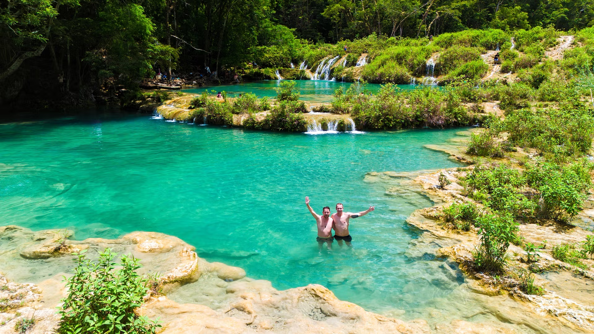
The Turquoise Pools
Six pools step down the 300m bridge, each separated by a travertine dam—shallow enough to stand, deep enough to swim. The turquoise color comes from dissolved limestone, the same mechanism as Plitvice. Clearest in dry season. EcoVoyager groups arrive in the afternoon, avoiding the mid-morning rush.
Cahabón River Tubing and Rafting
The Cahabón below the bridge exits the cave with force before calming downstream. Tubing on calmer sections and kayaking Class II–III gorge runs above Lanquín are available additions. EcoVoyager can combine river activities with the pools and K'anba into a two-day program based in Lanquín.
Birding the Alta Verapaz Jungle: The Quetzal Region
The route from Cobán passes through the Biotopo Mario Dary Rivera, Guatemala's most reliable quetzal site during March–June. The pools host howler monkeys, toucans, aracaris, and motmots. EcoVoyager builds multi-day programs pairing cloud forest birding with lowland jungle at Semuc Champey.
Q'eqchi' Maya Lanquín
The Cahabón valley is Q'eqchi' Maya territory—Guatemala's largest Maya linguistic group with around one million speakers. Semuc Champey translates as "where the river hides under the earth," still holding sacred significance. EcoVoyager works exclusively with Q'eqchi' guides from Lanquín for all in-
Design Your Custom Trip
Tell us about your dream adventure. Our travel specialists respond within 24 hours with a personalised itinerary.

Stories from Semuc Champey
How a River Made a Bridge: The Geology of Semuc Champey
The Cahabón River carries dissolved calcium carbonate from Alta Verapaz’s karst highlands. Where it encounters a particular section of the landscape it has, over millennia, carved a tunnel through the bedrock—a process known as karst piracy, in which a river diverts underground rather than continuing at the surface. At Semuc Champey, virtually all of the Cahabón’s flow enters a cave at the upstream end of a 300-meter limestone slab, thunders through an underground passage, and re-emerges downstream. The slab above is left dry enough that a small fraction of the river seeps across its surface.
That surface flow deposits calcite on the slab as it loses carbon dioxide to the open air, gradually building up the low travertine dams that create the stepped pool system. Today the pools are approximately one meter deep in most places. The turquoise color reflects the high limestone content—the same mechanism that produces the colors at Croatia’s Plitvice Lakes or Turkey’s Pamukkale, not a product of exceptional purity but of specific chemistry. The monument was designated Monumento Natural Semuc Champey in 2005 under Decreto 025 and is administered by CONAP, Guatemala’s national protected areas council.
Explore More
Other Guatemala Destinations
Explore more destinations across Guatemala.
Monterrico & Pacific Coast
Monterrico is a fishing village on Guatemala's Pacific coast, on black volcanic sand separated from the mainland by the Canal...
ExploreLaguna Lachua National Park
Laguna Lachuá is a nearly perfectly circular karstic lake at the center of a 14,500-hectare tropical rainforest park in Alta...
ExploreQuetzaltenango
Quetzaltenango—Xela—sits at 2,330 m (7,640 ft) in western Guatemala's highland valley, ringed by volcanic peaks. Guatemala's second largest city, 61%...
ExploreRio Dulce & Livingston
Río Dulce is a 43 km river flowing east from Lake Izabal—Guatemala's largest lake—through the Boquerón Canyon to the Caribbean...
ExploreSierra de las Minas Biosphere Reserve
Sierra de las Minas is a 130 km mountain range in central-eastern Guatemala, designated a UNESCO Biosphere Reserve in 1990...
ExploreChichicastenango
Chichicastenango—Chichi to everyone who visits—is a K'iche' Maya highland town at 6,447 feet in the El Quiché department of Guatemala....
ExploreEl Mirador
El Mirador is a Preclassic Maya city buried in the jungle of northern Petén, near the Mexican border. Occupied from...
ExploreAcatenango & Fuego Volcanoes
Acatenango (3,976m) and Fuego (3,763m) form La Horqueta—a twin-volcano massif in the Sierra Madre, 29 km west of Antigua. Acatenango...
ExploreLake Atitlán
Lake Atitlán fills a volcanic caldera formed by the Los Chocoyos supervolcano eruption ~85,000 years ago. At 340 meters deep...
ExploreAntigua Guatemala
Founded in 1543 as Santiago de los Caballeros, Antigua served as capital of the Captaincy-General of Guatemala—governing all of Central...
ExploreTikal National Park
Rising above the largest tropical forest north of the Amazon, Tikal's temple-pyramids—the tallest at 65 meters—broke through the jungle canopy...
Explore