


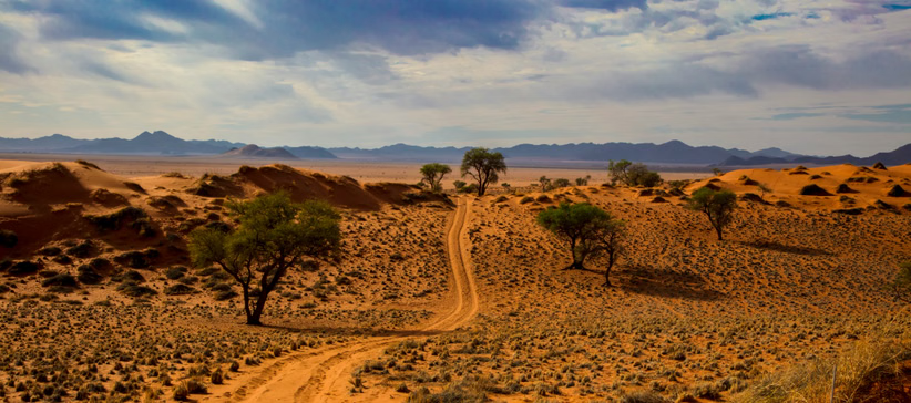


Damaraland
Damaraland, Namibia
Experience Damaraland, Your Way
Skip the standard itineraries. We design journeys around your interests, timeline, and curiosity with exclusive access you won't find on any platform.


Things to Do in Damaraland
Starting points for your perfect trip
Black Rhino Tracking on Foot
Join Save the Rhino Trust rangers to track critically endangered black rhinos through the Palmwag Concession. Leave your vehicle and follow ancient spoor across volcanic plains, approaching these magnificent creatures on foot—one of Africa's most thrilling conservation experiences.
Desert Elephant Encounter
Track desert-adapted elephants along the dry riverbeds of the Huab and Aba-Huab valleys. These remarkable animals can walk 70 kilometers daily in search of water, digging for moisture in sandy riverbeds. Watch family groups rest beneath ana trees as golden light floods the valley.
Twyfelfontein Rock Art at Sunset
Explore Namibia's first UNESCO World Heritage Site with a local guide as fading light illuminates 6,000-year-old San engravings. See the famous Dancing Kudu and Lion Man panels, where over 2,500 petroglyphs depict rhinos, elephants, giraffes, and spiritual beliefs of ancient hunter-gatherers.

Starlight Sleepout Experience
Fall asleep under some of the clearest night skies on Earth. Damaraland's remoteness means zero light pollution—watch the Milky Way arc overhead, spot the Southern Cross and Magellanic Clouds, and wake to desert silence broken only by birdsong at dawn.

Petrified Forest
Walk a geological timeline spanning 280 million years near Khorixas. The Petrified Forest preserves tree trunks up to 34 meters long, turned to stone by silicification. Nearby, Organ Pipes rise as 4-meter dolerite columns while Burnt Mountain glows fiery orange at sunrise.

Damara Living Museum
At the Damara Living Museum near Twyfelfontein, elders demonstrate traditions predating written history: fire-making by hand, leather tanning, medicine from desert plants, and bush food foraging. The Damara are among Namibia's oldest peoples, their click language linking them to the Khoisan.
Design Your Custom Trip
Tell us about your dream adventure. Our travel specialists respond within 24 hours with a personalised itinerary.
Where Ancient Giants Roam Free
A Closer Look at Damaraland

A Landscape Forged by Fire and Time
Damaraland occupies a vast swath of Namibia’s Kunene Region, wedged between the Skeleton Coast and Etosha National Park. This is a landscape shaped by cataclysmic forces—125 million years ago, when Africa and South America still formed the supercontinent Gondwana, massive volcanic eruptions created the basalt formations that define the region today. The Etendeka lava flows spread across nearly 600,000 hectares, while the Brandberg Massif—Namibia’s highest peak at 2,573 meters—rises dramatically from the surrounding plains.
But Damaraland’s geological wonders span far deeper time. Near Khorixas, the Petrified Forest preserves tree trunks up to 34 meters long and 6 meters in circumference—remnants of ancient forests that flourished 280 million years ago before being buried, mineralized, and eventually exposed by erosion. Nearby, the Organ Pipes showcase perfect hexagonal dolerite columns formed 150 million years ago, while Burnt Mountain’s clinker-like slopes reveal where molten magma baked ancient shales at temperatures exceeding 1,000°C.
The World's Last Free-Roaming Rhinos
In the early 1980s, poaching and drought had reduced Damaraland’s black rhino population to fewer than 40 individuals—extinction seemed inevitable. But in 1982, Save the Rhino Trust was founded, launching one of conservation’s greatest success stories. Today, the Palmwag Concession and surrounding conservancies shelter the largest population of free-roaming black rhinos outside any national park anywhere in the world.
What makes these rhinos unique is their freedom. They wander across 25,000 square kilometers of unfenced wilderness, tracked by local rangers who monitor every individual through detailed photographic records and intimate knowledge of the terrain. The desert-adapted subspecies (Diceros bicornis bicornis) has evolved remarkable behaviors—they can go several days without drinking and feed on the toxic Damara milk-bush that kills most other browsers. Tourism funds the rangers, creates employment, and gives communities a stake in the rhinos’ survival.
Desert Elephants, Ancient Rock Art & Living Culture
Damaraland’s desert-adapted elephants are among the most remarkable wildlife on Earth. Genetically identical to their savanna relatives, these elephants have developed extraordinary behaviors to survive—smaller body sizes, longer legs for covering vast distances, and the ability to detect underground water. Family groups walk ancient migration routes along ephemeral rivers like the Huab, Aba-Huab, and Hoanib, digging for water and teaching their young the survival skills passed down through generations.
Human presence here runs equally deep. At Twyfelfontein, UNESCO recognized Africa’s largest concentration of rock engravings—over 2,500 petroglyphs created by San hunter-gatherers over at least 2,000 years. The famous ‘Dancing Kudu’ and ‘Lion Man’ panels blend animal and human forms in spiritual imagery that still resonates today. Nearby, the Damara Living Museum preserves the traditions of one of Namibia’s oldest peoples—blacksmithing, leather-working, traditional medicine, and fire-making techniques that predate written history.
Explore More
Other Namibia Destinations
Explore more destinations across Namibia.
Walvis Bay Lagoon
Along Namibia's Atlantic coast, the world's oldest desert surrenders to the sea, creating one of Africa's most important wetlands. The...
ExploreHimba Villages
In Namibia's remote northwest, where the Kunene River marks the Angolan border, live the Himba — one of Africa's last...
ExploreSpitzkoppe
Rising 700 meters from the ancient Namib Desert floor, Spitzkoppe's granite peaks have stood sentinel for 120 million years —...
ExploreCaprivi Strip
Stretching like a narrow finger 450 kilometers into southern Africa, the Caprivi Strip, now officially the Zambezi Region, defies everything...
ExploreKolmanskop Ghost Town
Rising from the ancient Namib Desert lies Kolmanskop—a haunting testament to fortune and impermanence. In 1908, a railway worker discovered...
ExploreSwakopmund
Captain Curt von François founded Swakopmund on August 8, 1892, raising beacons on a shore where the Namib—the world's oldest...
ExploreWindhoek
Jonker Afrikaner, a powerful Oorlam leader from the Cape, established a settlement around Windhoek’s permanent hot springs in 1840, building...
ExploreFish River Canyon
The Nama people called this place ‘ai-gams’ and understood the canyon long before European surveyors reached it in the 1830s....
ExploreEtosha National Park
German colonial governor Friedrich von Lindequist proclaimed Etosha as Game Reserve No. 2 in 1907, responding to the near-extermination of...
ExploreSkeleton Coast
Portuguese sailors called this 500-kilometer Atlantic coastline ‘As Areias do Inferno’ in the 1500s, and the San people named it...
ExploreSossusvlei
The Namib has maintained arid conditions for 55 to 80 million years, making it the oldest desert on Earth, and...
Explore