


Travel to Samaipata
Where Three Worlds Converge
Samaipata
Where Three Worlds Converge

Ecovoyager Experiences
Samaipata Tours
Handcrafted expeditions into the remote corners of Samaipata, led by local experts, designed for the curious traveller.

Experience Samaipata, Your Way
Skip the standard itineraries. We design journeys around your interests, timeline, and curiosity with exclusive access you won't find on any platform.
Things to Do in Samaipata
Starting points for your perfect trip
El Fuerte de Samaipata: Sacred Stone at the Edge of Empire
Around 300 CE, carvers of the Mojocoyas culture began shaping this 220-meter sandstone monolith with puma forms, serpent channels, and rows of niches. The Inca later added ceremonial seats and terraces at the summit.
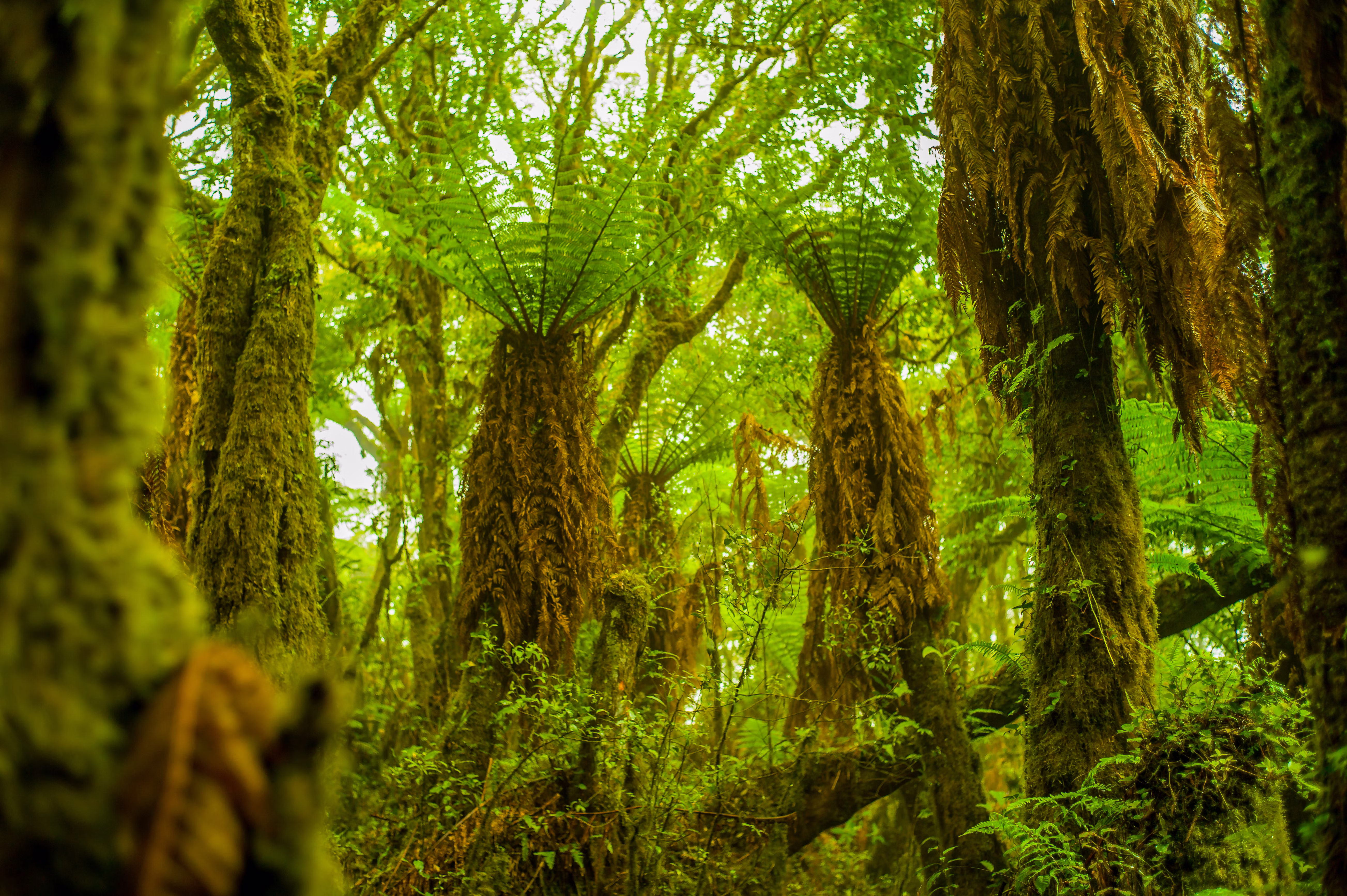
Jurassic Fern Forest Trek in Amboró
An hour north of Samaipata, Amboró National Park shelters giant tree ferns reaching 10 to 15 meters, an ancient lineage that dates to the age of the dinosaurs.
Andean Condor Expedition at El Nido de los Cóndores
Trek to a remote Andean cliff-side nesting site where condors ride thermals at eye level. Watch South America's largest flying bird launch from roosts just meters away, with expert guides timing arrivals to peak flight activity.
High-Altitude Wine Heritage of the Valles Cruceños
Spanish colonists planted Samaipata's first vines in the 1590s. At around 1,750 meters, Uvairenda continues this tradition among the higher commercial vineyards in the world.

Ruta del Che: Vallegrande & La Higuera
In 1967, Che Guevara was captured in the hills near La Higuera, beyond Vallegrande and roughly 120 kilometers from Samaipata, and executed the next day. His body was displayed in the laundry of Vallegrande's hospital, now a place of pilgrimage.

Las Cuevas & La Pajcha: Waterfall Canyons
Three waterfalls at Las Cuevas plunge into clear pools about 20 kilometers east of Samaipata. For a longer adventure, La Pajcha's roughly 40-meter cascade drops into a tropical pool some 42 kilometers south by 4x4, past valleys where parrots nest in sandstone cliffs.
Design Your Custom Trip
Tell us about your dream adventure. Our travel specialists respond within 24 hours with a personalised itinerary.
Where Three Worlds Converge
A Closer Look at Samaipata
Where Ancient Civilizations Converge
Rising from Bolivia’s eastern Andean foothills, the carved rock of El Fuerte de Samaipata tells a story spanning millennia. Around 300 CE, peoples of the Mojocoyas culture, later associated with the Chané, began sculpting this 220-meter sandstone monolith with pumas, serpents, and geometric channels of deep spiritual meaning. When the Inca expanded eastward in the late 15th century, they took this sacred site into their empire, adding carved seats, ceremonial channels, and an administrative complex that may have served as a regional center.
Today El Fuerte is a UNESCO World Heritage Site, inscribed in 1998, and a carved rock UNESCO describes as without parallel anywhere in the Americas. Its surface bears witness to three cultures: the deep grooves of the serpent channels, the Inca circle of carved niches at the summit, sometimes called the choir of priests and counted at around eighteen, and even traces of Spanish colonial occupation. At sunrise and sunset the red sandstone glows with an almost otherworldly intensity, while condors often soar overhead, a scene little changed since the site’s ancient ceremonial days.
The Living Laboratory of Amboró
Just an hour from Samaipata lies one of Earth’s most biodiverse protected areas. Amboró National Park occupies a rare position at the Elbow of the Andes, where three distinct ecosystems converge: the Amazon Basin, the Andean highlands, and the Gran Chaco lowlands. This confluence creates conditions found in few other places, supporting over 800 bird species, roughly 60 percent of all the birds recorded in Bolivia, along with more than 170 mammal species, some 3,000 documented plants, and many more still uncatalogued.
Among the park’s most remarkable inhabitants is the spectacled bear, or jucumari, South America’s only bear species and increasingly rare across its range. Jaguars, pumas, ocelots, and giant anteaters move through the forest, while military macaws, the Andean cock-of-the-rock, and the endangered horned curassow flash through the canopy. Perhaps most striking are the giant fern forests, where tree ferns reaching 10 to 15 meters create a prehistoric atmosphere, a living lineage that dates to the age of the dinosaurs.
From Cloud Forests to Vineyards
Samaipata’s name comes from Quechua and means rest in the heights, and the town has drawn seekers of calm for centuries. Spanish colonists planted vineyards here in the 1590s, finding that the cool nights, warm days, and well-drained slopes suited the vine. Today boutique wineries like Uvairenda carry on this four-century tradition, making acclaimed Tannat and Torrontés at around 1,750 meters, among the higher commercial vineyards in the world.
The town keeps its colonial charm, with cobblestone streets, adobe buildings, and a bohemian air that has drawn artists and expatriates from around the world. Beyond the wine, the surrounding valleys invite endless exploration: the three waterfalls at Las Cuevas spill into swimmable pools, La Pajcha’s roughly 40-meter falls drop into a cathedral-like grotto, and the trek to El Nido de los Cóndores reaches one of South America’s finest places to watch Andean condors, where a good morning brings fifteen to thirty birds and exceptional days far more.
Explore More
Other Bolivia Destinations
Explore more destinations across Bolivia.
Barba Azul Nature Reserve
In the heart of Bolivia's Beni savanna, the Barba Azul Nature Reserve protects 12,200 hectares of seasonally flooded grassland, palm...
ExploreTarija Wine Country
In the far south of Bolivia, near the Argentine border, the city of Tarija and the surrounding valleys form the...
ExploreNoel Kempff Mercado
Spread across 1,523,446 hectares of remote northeastern Bolivia along the Brazilian border, Noel Kempff Mercado is one of South America's...
ExploreKaa-Iya National Park
Larger than Belgium and home to one of the largest jaguar populations in South America, Kaa-Iya del Gran Chaco is...
ExploreEduardo Avaroa Andean Fauna National Reserve
On Bolivia's altiplano above 4,200 meters, in the country's far southwestern corner where it meets Chile and Argentina, lies one...
ExploreSanta Cruz de la Sierra
In Bolivia's tropical lowlands, where the Andes tumble into the Amazon, Santa Cruz opens doors to landscapes found nowhere else...
ExploreAmboro National Park
At the Elbow of the Andes, where the mountains bend westward toward Peru, Amboró National Park sits at one of...
ExploreSucre
Founded in 1538 as Ciudad de la Plata by Spanish colonists profiting from nearby Potosí's silver mines, Sucre grew into...
ExplorePotosí
In 1545, an indigenous prospector named Diego Huallpa found silver on a mountain the Inca had long held sacred. Within...
ExploreMadidi National Park
Identified by Wildlife Conservation Society researchers as probably the most biodiverse protected area on Earth, Madidi spans nearly 19,000 square...
ExploreNorth Yungas Road
Carved into sheer cliffs in the 1930s, the North Yungas Road, El Camino de la Muerte, is estimated to have...
ExploreLake Titicaca
At 3,812 meters, Lake Titicaca stretches across the Andean altiplano like a shimmering inland sea, the highest navigable lake in...
ExploreSalar de Uyuni
At 3,656 meters on the Bolivian Altiplano lies the world's largest salt flat, a 10,582-square-kilometer expanse of crystalline white that...
ExploreLa Paz
Perched between 3,250 and 4,100 meters above sea level, La Paz defies gravity and expectations as the world's highest administrative...
Explore