


Travel to Salar de Uyuni
Where Earth Becomes Sky
Salar de Uyuni
Where Earth Becomes Sky


Ecovoyager Experiences
Salar de Uyuni Tours
Handcrafted expeditions into the remote corners of Salar de Uyuni, led by local experts, designed for the curious traveller.
 Featured
SALAR DE UYUNI
The Great Bolivian Traverse: Amazon to Altiplano
A 25-day expedition from the Amazon basin to the Salar de Uyuni, Lake Titicaca, and the remote Apolobamba range


Experience Salar de Uyuni, Your Way
Skip the standard itineraries. We design journeys around your interests, timeline, and curiosity with exclusive access you won't find on any platform.

Things to Do in Salar de Uyuni
Starting points for your perfect trip
Mirror of the Sky
In the rainy season, a thin sheet of water turns the Salar into the world's largest mirror, where sky and earth merge into one seamless reflection and the horizon all but disappears.
Milky Way Stargazing
At 3,656 meters with almost no light pollution, the Salar offers some of Earth's clearest night skies. In the wet season the Milky Way reflects in the water below, until you seem to float among the stars.
Ancient Cactus Island
Hike Incahuasi Island, where giant cacti thought to be over a thousand years old tower above fossil coral, and the short climb to the summit opens onto a sea of white salt stretching to the horizon.

Flamingo Lagoons & Geysers
Explore the Eduardo Avaroa reserve's blood-red Laguna Colorada, where three flamingo species gather, including the rare James's flamingo, then stand among the Sol de Mañana fumaroles at dawn as steam plumes rise tens of meters into the cold air.
Cycling Across the Salt Flat
Ride a mountain bike straight out across the hard salt crust, with the horizon flat in every direction and the white surface stretching past the limits of sight. A support vehicle carries water, layers, and gear while you pedal toward Tunupa or the cactus islands. This is a dry-season ride, when the crust is firm and the going is fast.
A Night Beside the Islands
Camp for a night beside one of the salt flat's islands, under some of the darkest skies on Earth. As the sun drops, the Milky Way blazes overhead and, in the wet season, doubles in the water at your feet. Permitted dome and tented camps keep you warm against the deep highland cold, and sunrise over the salt is the reward.
The Mummies of Tunupa
On the northern shore near the village of Coquesa, a cave in the lower slopes of Tunupa shelters a group of naturally preserved mummies, seated and wrapped as they were laid to rest. Dried by the cold, thin air, they date to the centuries before the Inca, roughly seven to nine hundred years ago. Visits are made quietly and with respect, guided by the local community.
Walking with a Llama Caravan
For centuries, Aymara and Quechua herders led llama caravans across the Altiplano, carrying Uyuni's salt to trade for maize and grain from the lowland valleys. In the villages on the salt flat's northern edge, you can walk alongside a working caravan of these pack animals and meet the families who still keep the salt-trading tradition alive.
Design Your Custom Trip
Tell us about your dream adventure. Our travel specialists respond within 24 hours with a personalised itinerary.
Where Earth Becomes Sky
A Closer Look at Salar de Uyuni

Born from Ancient Waters
Tens of thousands of years ago, what is now the world’s largest salt flat lay beneath a vast prehistoric lake. Lake Minchin, a giant inland sea that by some estimates once covered much of southwestern Bolivia’s Altiplano, began the slow transformation that would create one of Earth’s most extraordinary landscapes. As the climate shifted and the Andes kept rising, this ancient water gave way through later lakes known as Tauca and Coipasa before drying almost completely around eleven thousand years ago.
That evaporation left a crystalline legacy: some 10 billion tons of salt spread across 10,582 square kilometers at 3,656 meters, a surface so flat it varies by less than a meter from end to end. That flatness makes the Salar so useful for calibrating satellite altimeters from orbit that agencies have used it to fine-tune instruments like NASA’s ICESat. Beneath the crust lies a brine holding one of the world’s largest lithium resources, by United States Geological Survey figures roughly a fifth of all the lithium identified on Earth and the largest such resource of any country, though very little has yet been commercially extracted.
The Mirror of the Gods
Long before geologists explained its formation, the Aymara told a different story of how the Salar de Uyuni came to be. In their tradition, the towering peaks around the salt flat, Tunupa, Kusku, and Kusina, were once giants who lived among the clouds. The legend tells of Tunupa, who married Kusku but was abandoned when he fled with Kusina, leaving her heartbroken and alone on what is now the 5,321-meter dormant volcano that bears her name.
As Tunupa grieved while nursing her newborn son, her tears mixed with her milk and flooded the land below, creating the vast white expanse. This is why many Aymara still call the salt flat Salar de Tunupa, honoring the mountain whose sorrow they believe gave birth to this otherworldly place. Tunupa remains sacred ground, and on its lower slopes, near the village of Coquesa, naturally preserved mummies still rest in a cave looking out over the salt.
Islands of Time & Salt
Rising from the endless white like mirages made real, the islands of the Salar are the tops of ancient volcanoes that stood above the water when prehistoric lakes covered the Altiplano. Incahuasi Island, meaning House of the Inca in Quechua, climbs about 80 meters above the salt to its summit viewpoint, its rocky surface crusted with fossil coral and algal stromatolites that recall the ancient waters that once filled this basin.
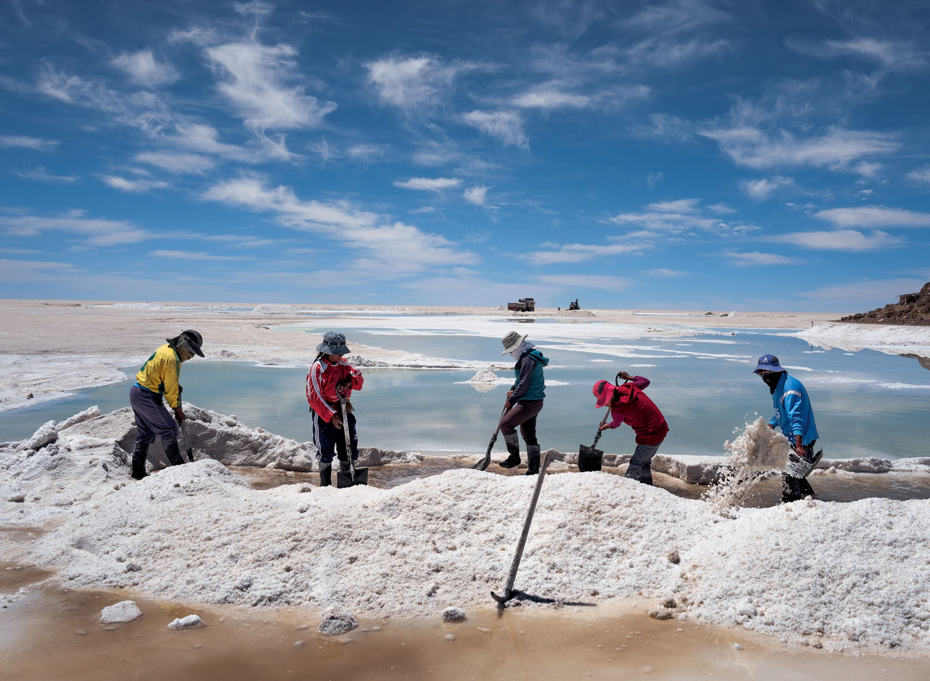
The islands are crowned with giant cacti, some reaching 12 meters and, growing barely a centimeter a year, thought to be over a thousand years old. These slow sentinels have stood through much of the human history of the Altiplano. At the salt flat’s edge, the village of Colchani, home to around 600 people, still harvests salt by hand, raking the white crystals into the conical mounds that dot the shoreline. Only about 25,000 tons are taken each year from an estimated 10 billion, so the landscape will endure for countless generations.
From the Journal
Stories from Salar de Uyuni
Field notes, cultural encounters, and trail dispatches from our guides and travellers in Salar de Uyuni.


Explore More
Other Bolivia Destinations
Explore more destinations across Bolivia.
Barba Azul Nature Reserve
In the heart of Bolivia's Beni savanna, the Barba Azul Nature Reserve protects 12,200 hectares of seasonally flooded grassland, palm...
ExploreTarija Wine Country
In the far south of Bolivia, near the Argentine border, the city of Tarija and the surrounding valleys form the...
ExploreNoel Kempff Mercado
Spread across 1,523,446 hectares of remote northeastern Bolivia along the Brazilian border, Noel Kempff Mercado is one of South America's...
ExploreKaa-Iya National Park
Larger than Belgium and home to one of the largest jaguar populations in South America, Kaa-Iya del Gran Chaco is...
ExploreEduardo Avaroa Andean Fauna National Reserve
On Bolivia's altiplano above 4,200 meters, in the country's far southwestern corner where it meets Chile and Argentina, lies one...
ExploreSanta Cruz de la Sierra
In Bolivia's tropical lowlands, where the Andes tumble into the Amazon, Santa Cruz opens doors to landscapes found nowhere else...
ExploreAmboro National Park
At the Elbow of the Andes, where the mountains bend westward toward Peru, Amboró National Park sits at one of...
ExploreSamaipata
Around 300 CE, peoples of the Mojocoyas culture, later associated with the Chané, began sculpting a 220-meter sandstone monolith with...
ExploreSucre
Founded in 1538 as Ciudad de la Plata by Spanish colonists profiting from nearby Potosí's silver mines, Sucre grew into...
ExplorePotosí
In 1545, an indigenous prospector named Diego Huallpa found silver on a mountain the Inca had long held sacred. Within...
ExploreMadidi National Park
Identified by Wildlife Conservation Society researchers as probably the most biodiverse protected area on Earth, Madidi spans nearly 19,000 square...
ExploreNorth Yungas Road
Carved into sheer cliffs in the 1930s, the North Yungas Road, El Camino de la Muerte, is estimated to have...
ExploreLake Titicaca
At 3,812 meters, Lake Titicaca stretches across the Andean altiplano like a shimmering inland sea, the highest navigable lake in...
ExploreLa Paz
Perched between 3,250 and 4,100 meters above sea level, La Paz defies gravity and expectations as the world's highest administrative...
Explore