


Travel to Aral Sea & Aralsk
Aral Sea, Kazakhstan
Aral Sea & Aralsk
Aral Sea, Kazakhstan
Experience Aral Sea & Aralsk, Your Way
Skip the standard itineraries. We design journeys around your interests, timeline, and curiosity with exclusive access you won't find on any platform.


Things to Do in Aral Sea & Aralsk
Starting points for your perfect trip
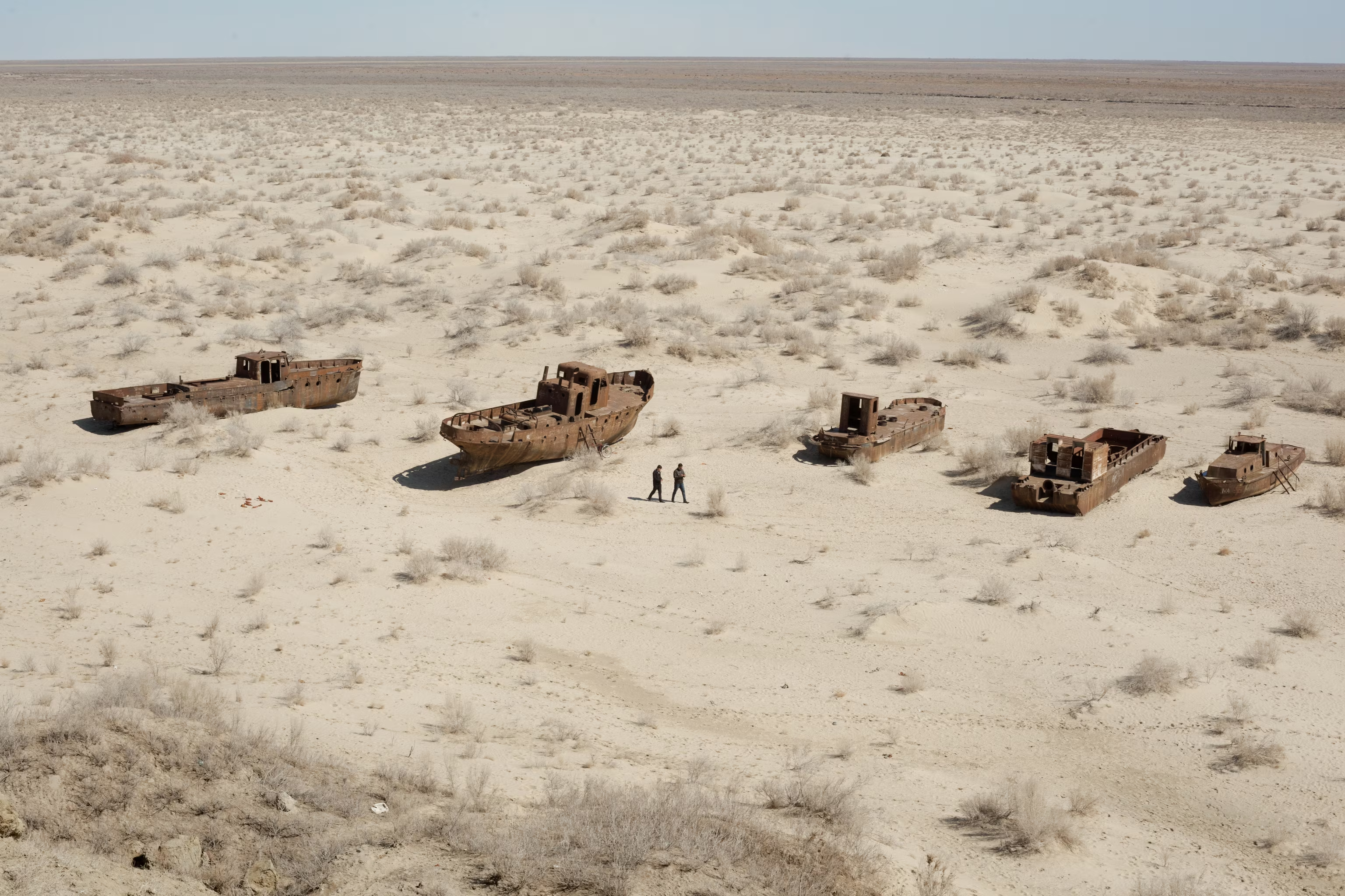
Ship Graveyard Expedition
Drive by 4x4 to Zhalanash ship cemetery, where rusting Soviet trawlers sit stranded on sand that was 40m underwater. The fleet supplied 10% of the USSR's inland fish catch; hulks are disappearing as scrap dealers dismantle them. Camels graze between the rusting hulls.
North Aral Sea & Kokaral Dam
The Kokaral Dam (2005, World Bank) separates the recovering North Aral Sea from the abandoned South. Water levels rose 12m, salinity dropped from 30 to 8 g/L, and the fish catch recovered to 8,000 tons. Drive the dam to see the contrast between the two basins.
Aralsk: Portrait of a Stranded Port
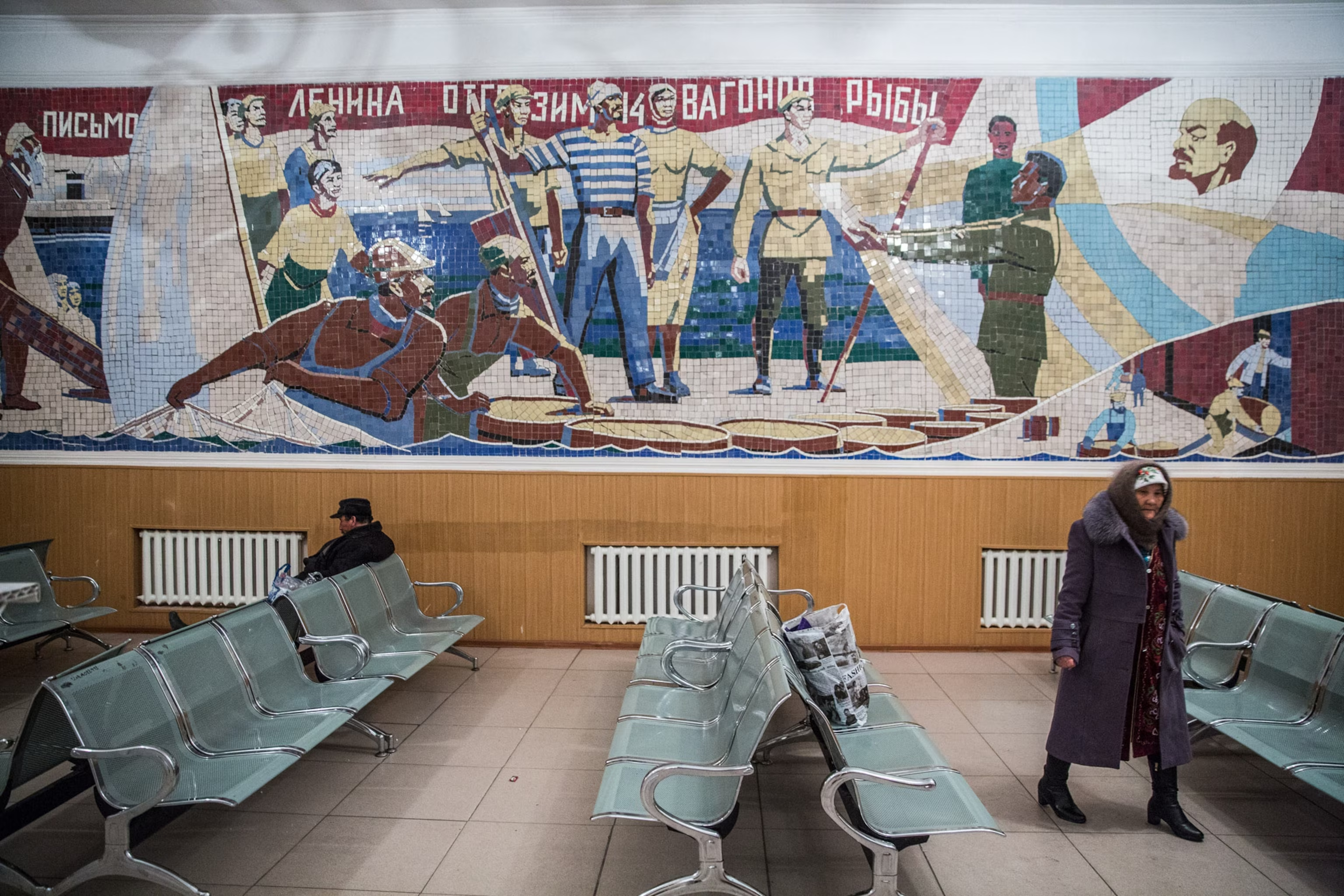
Aralsk, founded in 1905 as the Aral Sea's main fishing hub, retains rusting harbor infrastructure, a train station mosaic commemorating fishermen feeding post-Revolution Russia, and a museum documenting the shoreline's retreat. The industry's collapse triggered mass out-migration

Aralkum Desert & Toxic Seabed
The Aralkum covers four million hectares of former lakebed where Soviet-era pesticide residues generate toxic dust storms reaching 500 km. Kazakhstan's saxaul planting initiative has reforested 475,000 hectares since 2021, stabilizing soil across what was recently barren salt flat.

Vozrozhdeniya Island: Cold War Bioweapons Legacy
Vozrozhdeniya Island hosted Aralsk-7, a secret Soviet bioweapons facility from 1948 testing anthrax, plague, and smallpox. A 1971 accidental release infected Aralsk residents, killing three. As the sea receded, the island merged with the mainland by 2001, raising concerns about buried stockpiles.
Design Your Custom Trip
Tell us about your dream adventure. Our travel specialists respond within 24 hours with a personalised itinerary.
The World’s Greatest Environmental Disaster & Its Comeback
A Closer Look at Aral Sea & Aralsk
The Making of a Catastrophe
Until the mid-20th century, the Aral Sea was the fourth-largest lake on Earth, covering 68,000 square kilometers between Kazakhstan and Uzbekistan with a maximum depth of 40 meters. Its name, derived from Turkic and Mongolic languages, means Sea of Islands, a reference to the more than 1,100 islands that once dotted its waters. The Aral supported a robust fishing industry harvesting over 20 commercially valuable species, a shipping trade connecting the port of Aralsk to river ports as far as Tajikistan, and a Soviet naval flotilla that had operated since 1847 when imperial Russia first assembled warships on its shores. The surrounding region was home to millions of people whose livelihoods depended on the sea’s abundance.
In the 1960s, Soviet central planners diverted approximately 75 percent of the flow from the Amu Darya and Syr Darya rivers to irrigate cotton, rice, and cereal fields across the arid Central Asian steppe. By 1988, the program had made Uzbekistan the world’s largest cotton exporter, but the cost was catastrophic. Poor-quality irrigation infrastructure meant that most diverted water evaporated or leaked before reaching crops. The sea began shrinking irreversibly. By the 2000s, it had lost over 90 percent of its original area and dropped 75 feet, splitting into four disconnected remnants: the North Aral Sea in Kazakhstan, the eastern and western basins of the much larger South Aral Sea, and a small intermediate lake. Former UN Secretary-General Ban Ki-moon, visiting in 2011, called it one of the planet’s worst environmental disasters.
Aralsk: A Port Stranded by History
Aralsk came into being with the arrival of the Tashkent–Orenburg railway in 1905 and rapidly developed into the principal fishing port on the northern Aral Sea. At its peak, the town’s fleet processed thousands of tons of fish annually, and the local industry famously answered Lenin’s cry for help by dispatching trainloads of catch to feed the hunger-stricken Soviet population after the revolution—an episode immortalized in a socialist-realist mosaic that still decorates the Aralsk train station. Parallel to Muynak at the sea’s southern end in Uzbekistan, Aralsk served as the northern anchor of an entire economic ecosystem built around the Aral’s abundance.
As the sea retreated, Aralsk’s waterfront infrastructure was left high and dry. The fishing fleet was abandoned, the canning factories shuttered, and the harbor cranes rusted in place as the shoreline retreated nearly 100 kilometers to the south. Independent research suggests the lake’s collapse triggered the displacement of between 100,000 and 700,000 people from the broader region by the 1990s. Those who remained faced rising unemployment, contaminated water supplies, and severe health impacts from toxic dust storms blowing off the exposed seabed. Life expectancy in the Kyzylorda region declined from 64 to 51 years. Today Aralsk’s population persists in a community largely supported by the restoration project’s economic ripple effects and, increasingly, by visitors who come to witness the aftermath.
Vozrozhdeniya: The Secret Island
Among the most chilling chapters of the Aral Sea’s history is Vozrozhdeniya Island, Russian for Rebirth, where the Soviet military operated a top-secret biological weapons testing facility from 1948. Code-named Aralsk-7, the laboratory sat at the center of the sea on an island that never appeared on Soviet maps, accessible only by military transport. The facility tested weaponized strains of anthrax, smallpox, plague, tularemia, brucellosis, and Venezuelan equine encephalitis in outdoor pens and aerosol chambers, supported by a garrison town of approximately 1,500 inhabitants complete with housing blocks, schools, shops, a sports stadium, and an airfield. Before its abandonment, the Soviets used the island as a dumping ground for their stockpiles of weaponized anthrax.
Accidents were inevitable. In 1971, an explosion released weaponized smallpox in a yellow cloud that drifted across the open water. A scientist on a research vessel crossing the sea was infected despite being vaccinated, and upon returning to Aralsk she unknowingly spread the disease to nine others, three of whom died. Fishermen were found dead on boats with no visible trauma. In 1976, massive fish kills occurred without explanation, and in 1988, half a million saiga antelope dropped dead within hours downwind of the island. As the Aral Sea retreated, Vozrozhdeniya became a peninsula by 2001 and then merged entirely with the mainland, raising international concerns about contamination spreading from the hastily abandoned facility into the surrounding desert.
Explore More
Other Kazakhstan Destinations
Explore more destinations across Kazakhstan.
Semipalatinsk Nuclear Test Site
Between 1949 and 1989, the Soviet Union detonated 456 nuclear devices across 18,000 square kilometers of Kazakh steppe in a...
ExploreAksu-Zhabagly Nature Reserve
Founded in 1926, Aksu-Zhabagly is Central Asia's oldest nature reserve and one of the most biodiverse protected areas in the...
ExploreBaikonur Cosmodrome
On 4 October 1957, from a launch pad in the remote Kazakh steppe, a modified intercontinental ballistic missile hurled a...
ExploreKaton-Karagay National Park
At the far eastern edge of Kazakhstan, where four nations converge in the Altai Mountains, lies the country's largest national...
ExploreIle-Alatau National Park
Minutes from Kazakhstan's largest city, yet worlds away from it. Ile-Alatau National Park wraps around Almaty's southern edge, rising from...
ExploreTurkestan
Southern Kazakhstan's ancient capital has been a pilgrimage destination for 900 years. Turkestan—called Yasi until the 16th century, when it...
ExploreMangystau & Bozzhira Valley
Western Kazakhstan’s Mangystau region covers 165,600 square kilometers of former Tethys Ocean floor where chalk cliffs, salt flats, and colored...
ExploreKorgalzhyn Nature Reserve
Established in 1968 and inscribed as Kazakhstan's first natural UNESCO World Heritage Site in 2008, Korgalzhyn protects 543,171 hectares of...
ExploreAstana
Founded in 1830 as a Russian Cossack outpost on the Ishim River, Astana became Kazakhstan's capital on December 10, 1997....
ExploreAltyn-Emel National Park
Established in 1996 in the Ili River valley 250 km northeast of Almaty, Altyn-Emel—"Golden Saddle" in Kazakh—is Kazakhstan's largest national...
ExploreKolsai Lakes
Established in 2007 on the northern slopes of the Kungei Alatau range, Kolsai Lakes National Park holds three vertically stacked...
ExploreCharyn Canyon
Charyn National Park, established in 2004 and expanded to 127,050 hectares in 2009, protects a 154-kilometer canyon carved by the...
ExploreAlmaty
Kazakhstan's largest city and former capital (1929–1997), Almaty sits at 700–900 meters in the foothills of the Trans-Ili Alatau—the northernmost...
Explore