


Travel to Hunza Valley
Hunza Valley, Pakistan
Hunza Valley
Hunza Valley, Pakistan
Experience Hunza Valley, Your Way
Skip the standard itineraries. We design journeys around your interests, timeline, and curiosity with exclusive access you won't find on any platform.


Things to Do in Hunza Valley
Starting points for your perfect trip
Ancient Fort & Silk Road Journey
Explore the 1,100-year-old Altit Fort and 700-year-old Baltit Fort, both UNESCO-recognized heritage sites where Mirs ruled mountain kingdoms for centuries. Walk Ganish Village's thousand-year-old lanes and decipher petroglyphs at the Sacred Rocks of Haldeikish in six ancient scripts.
Glacier & Cathedral Peak Trek
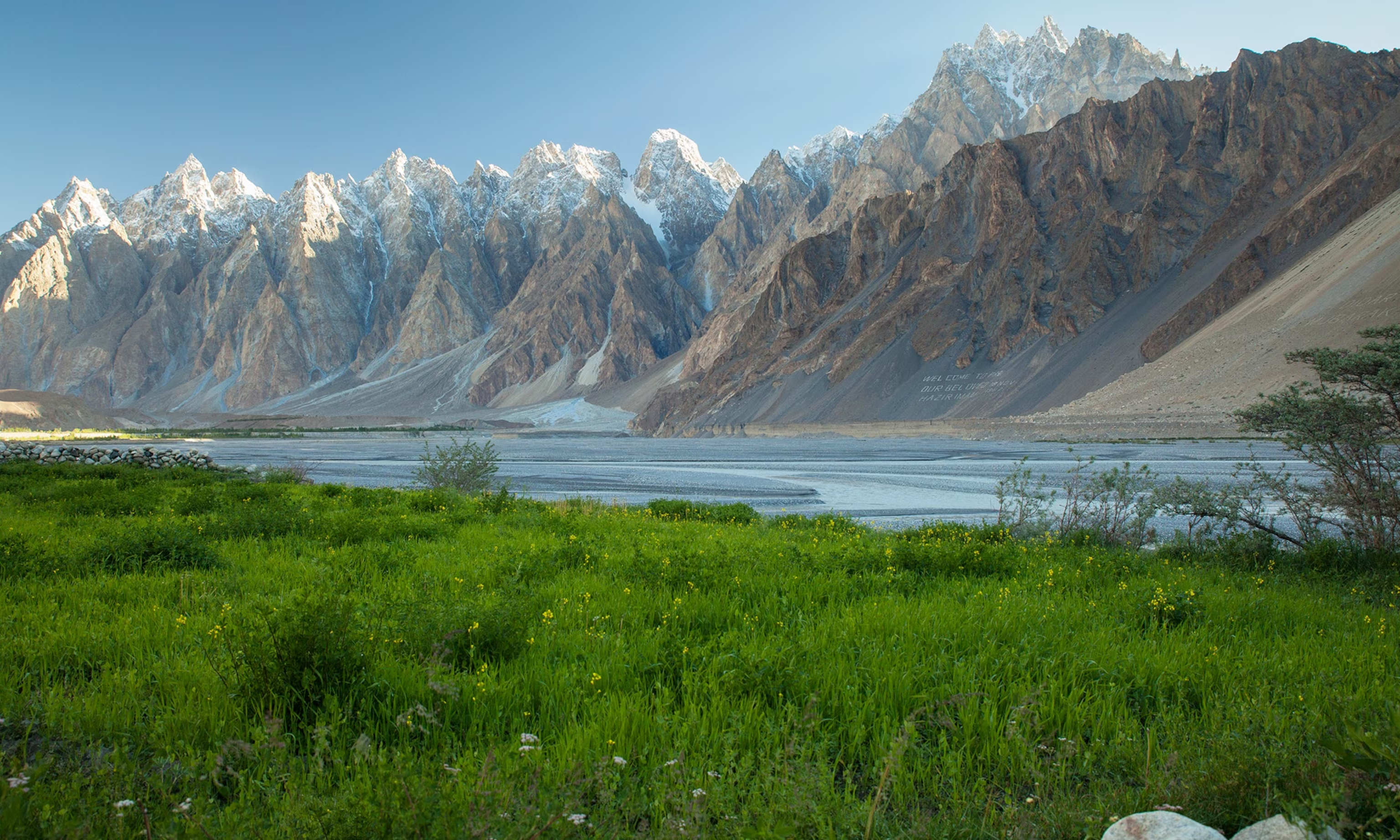
Trek across Passu Glacier beneath the 6,106-meter Tupopdan—the Cathedral Peaks whose jagged spires are Pakistan's most photographed mountains. Cross the legendary Hussaini Suspension Bridge and hike toward the 56-kilometer Batura Glacier, the world's seventh-longest outside polar regions.
Khunjerab Wildlife & Border Expedition
Journey to Khunjerab National Park at 4,693 meters—the world's highest paved border crossing. Search for Marco Polo sheep with their magnificent spiraling horns, scan rocky outcrops for elusive snow leopards, and spot Siberian ibex on slopes where the Karakoram meets the Chinese frontier.

Burusho Cultural Immersion
Stay with Burusho families who speak Earth's most mysterious language isolate. Learn to prepare chapshuro meat pies and apricot-based dishes, taste organic walnuts and dried fruits, and experience Ismaili traditions in a community renowned for its 90%+ literacy rate and progressive values.
Attabad Lake & Friendship Tunnels
Boat across turquoise Attabad Lake—born when a 2010 landslide dammed the Hunza River, creating a 21-kilometer lake reaching 100-meter depths that submerged villages and severed the Karakoram Highway. Drive through the five Pakistan-China Friendship Tunnels totaling 7 km that restored the road.
Rakaposhi Viewpoint & Eagle's Nest Trek
Hike to Eagle's Nest viewpoint above Duiker village for a 360-degree panorama encompassing 7,788-meter Rakaposhi, Diran Peak, Golden Peak, and the full sweep of the Hunza Valley below. Time the trek for sunrise or sunset when the Karakoram skyline glows pink and gold.
Design Your Custom Trip
Tell us about your dream adventure. Our travel specialists respond within 24 hours with a personalised itinerary.
Where Ancient Forts Guard the Roof of the World
A Closer Look at Hunza Valley

Where Mountain Ranges Collide
In northern Pakistan, where the borders of China and Afghanistan converge, three of Earth’s greatest mountain ranges meet in a collision of geological titans. The Karakoram, Himalayas, and Hindu Kush create an amphitheater of peaks surrounding the Hunza Valley—a 7,900 square kilometer realm of terraced orchards, glacial rivers, and villages perched at 2,438 meters elevation. More than a dozen summits exceeding 7,000 meters ring the valley: Rakaposhi at 7,788 meters dominates the southern horizon, while Ultar Sar’s 7,388-meter ice walls loom directly above the ancient capital of Karimabad. To the north, the 56-kilometer Batura Glacier—the world’s seventh-longest outside polar regions—feeds the Hunza River’s turquoise waters.
This landscape was forged by the same tectonic forces that created the Himalayas, and it continues to reshape itself dramatically. On January 4, 2010, a massive landslide thundered down the valley walls, damming the Hunza River and creating Attabad Lake—a 21-kilometer turquoise jewel now reaching depths of over 100 meters. The catastrophe submerged villages and severed the Karakoram Highway, yet the lake has become one of Pakistan’s most striking natural attractions. Engineers responded by boring five tunnels totaling 7 kilometers through the mountains—the Pakistan-China Friendship Tunnels—restoring the legendary highway that traces ancient Silk Road caravan routes.
Silk Road Kingdom & Ancient Scripts
For over two millennia, Hunza controlled vital Silk Road routes connecting Central Asia to the Indian subcontinent. Caravans carrying silk, spices, and gemstones passed through mountain corridors guarded by the Mirs—hereditary rulers who built fortress palaces on strategic ridges. Baltit Fort, founded in the 8th century and expanded over 700 years, stands below the Ulter Glacier with commanding views of all approaches. Its Tibetan-influenced architecture arrived with Princess Shah Khatoon of Baltistan in the 16th century, whose craftsmen transformed the fortress in the style of Lhasa’s Potala Palace. The older Altit Fort, its Shikari watchtower dating back 1,100 years, represents the oldest standing monument in Gilgit-Baltistan.
The Sacred Rocks of Haldeikish preserve an extraordinary record of those who traveled these routes. On boulders stretching 180 meters along the ancient trail, petroglyphs spanning the first millennium AD appear in Sogdian, Bactrian, Kharosthi, Brahmi, Tibetan, and Chinese scripts—a visual encyclopedia of Silk Road diversity. Names of Kushan emperors Kanishka and Huvishka are carved here, along with an inscription declaring ‘Chandra Sri Vikramaditya conquers’ dated to 419 AD, suggesting the Gupta Empire’s reach extended into these mountain passes. Buddhist pilgrims left images of stupas; merchants recorded their passage; ibex carvings gave the site its name—Haldeikish means ‘place of many male ibex’ in Burushaski.
The Burusho & the Mystery Language
The Burusho people, numbering approximately 120,000, have inhabited these valleys for millennia, yet their origins remain one of anthropology’s enduring mysteries. They speak Burushaski—a language isolate with no demonstrated relationship to any other language on Earth. Like Basque in Europe, Burushaski stands alone, its complex grammar featuring four genders and intricate verb conjugations that linguists have attempted unsuccessfully to connect to Tibetan, Indo-European, Dravidian, and dozens of other language families. This linguistic isolation suggests the Burusho may descend from pre-Indo-Aryan inhabitants pushed into these mountain refuges around 1800 BCE.
Today’s Burusho are predominantly Ismaili Muslims, followers of the Aga Khan, whose development initiatives have transformed the region. Hunza boasts Pakistan’s highest literacy rates—exceeding 90%—with particular emphasis on women’s education rare in this part of the world. The community maintains distinctive traditions: chapshuro meat pies, gyaling pancakes dipped in apricot oil, and dishes sweetened with organic walnuts grown on terraced slopes. The apricot orchards alone number over 50 varieties, their kernels pressed for oil used in cooking and cosmetics, their fruit dried for winter sustenance as they have been for centuries. In spring, the valley transforms into a sea of pink and white blossoms beneath snow-capped peaks—a scene that inspired James Hilton’s 1933 novel Lost Horizon and its mythical Shangri-La.
Explore More
Other Pakistan Destinations
Explore more destinations across Pakistan.
Deosai National Park
Rising above 4,000 meters in the western Himalayas lies Deosai—the second-highest plateau on Earth and one of Pakistan’s last truly...
ExploreMakli Necropolis
When the Sufi saint Sheikh Hamad Jamali established his khanqah on this limestone plateau in the 14th century, he set...
ExploreHarappa
Before Egypt’s pyramids reached their golden age, before classical Greece was imagined, the people of Harappa had already mastered urban...
ExplorePeshawar
Where empires carved their path through the Khyber Pass, Peshawar stands as one of South Asia’s oldest continuously inhabited cities—2,500...
ExploreKarachi
Pakistan's largest city sprawls along the Arabian Sea where Baloch fishermen built the village of Kolachi and Alexander's admiral Nearchus...
ExploreMohenjo-daro
Five thousand years ago, when Stonehenge was just beginning and the Egyptian pyramids were newly built, a city of 40,000...
ExploreTaxila Pakistan
Before Oxford or Bologna existed, students from across Asia gathered in Taxila to study medicine, mathematics, and philosophy under the...
ExploreKhunjerab Pass
At 4,693 meters, Khunjerab Pass is the world’s highest paved international border crossing—the dramatic culmination of the Karakoram Highway where...
ExploreIslamabad
This is the threshold of the high places. Islamabad rises where the Pothohar Plateau meets the Margalla Hills—a planned capital...
ExplorePassu
The Passu Cones pierce the sky like Gothic spires—a row of impossibly sharp peaks that locals call Tupopdan, ‘the sun-gulping...
ExploreNanga Parbat
At 8,126 meters, Nanga Parbat claimed 31 lives before Hermann Buhl reached its summit alone and without supplemental oxygen on...
ExploreK2 Base Camp
Stand at the foot of the world's second-highest mountain—and by many measures its most dangerous. K2 rises 8,611 meters above...
ExploreKarakoram Highway
They called it impossible—a road through the highest mountains on Earth. For 20 years, 24,000 Pakistani and Chinese workers carved...
ExploreSwat Valley
German mountaineers called it the Switzerland of the East, but Swat Valley's story runs far deeper than alpine beauty. This...
ExploreFairy Meadows
German mountaineers searching for a route to Nanga Parbat's summit named this alpine grassland Märchenwiese—'Fairy Tale Meadows'—struck by its otherworldly...
ExploreLahore
Where the Ravi River flows past marble palaces and minarets that have witnessed six centuries of empire, Lahore preserves the...
ExploreSkardu
Where the Indus and Shigar rivers converge beneath the world's greatest concentration of 8,000-meter peaks, Skardu commands the gateway to...
Explore