


Travel to Kel Suu Lake
A glacial lake swallowed by canyon walls
Kel Suu Lake
A glacial lake swallowed by canyon walls

Ecovoyager Experiences
Kel Suu Lake Tours
Handcrafted expeditions into the remote corners of Kel Suu Lake, led by local experts, designed for the curious traveller.
Experience Kel Suu Lake, Your Way
Skip the standard itineraries. We design journeys around your interests, timeline, and curiosity with exclusive access you won't find on any platform.


Things to Do in Kel Suu Lake
Starting points for your perfect trip
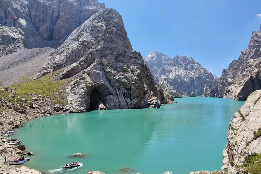
Canyon Boat Excursion to the Cave Island
Paddle into the northern canyon, cliffs rising hundreds of meters on both sides, to a 50 m rocky island riddled with caves. Enter the main cave—a large hall descending into two calcite-walled corridors. This section of the lake is unreachable on foot. Boats arranged through the Kok-Kiya yurt camps.
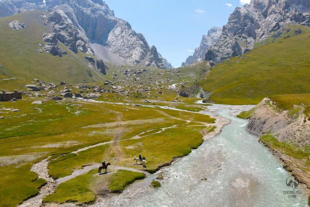
Horseback Ride Through the Kok-Kiya Valley
Hire a horse from the nomadic families in the valley and ride the 6 km approach to the lake—through wildflower steppe and along the Kurumduk River before the canyon walls close in. The traditional way to arrive at Kel Suu. Round trip 3–4 hours; all ability levels can be accommodated.
Overnight Camping at the Lake
Camp at the lakeshore at 3,514 m with no light pollution, no cell signal, and no other visitors. The Milky Way is visible in sharp detail on clear nights. Snow-capped peaks above 4,400 m frame the water at dawn. This is one of the most isolated overnight positions accessible by foot in Central Asia.
Yurt Stay with Nomadic Families in the Valley
Stay in a working nomadic yurt in the Kok-Kiya Valley, where Kyrgyz families bring their herds to the summer jailoo. Share a meal, watch yaks and horses on the high pastures, and sleep in a yurt that functions exactly as it has for centuries. Bookable through CBT Naryn.
Kayaking the Full Length of the Canyon
Paddle all 9 km of turquoise water between canyon walls. The southern end opens into green meadows; the northern section narrows into sheer cliff with caves and the rocky island. No motorized boats, no other groups—one of the most dramatic kayaking corridors in Central Asia.
Marco Polo Argali Trek on the High Steppe
The approach through the At-Bashi and Ak-Sai valleys passes prime habitat for the Marco Polo argali—the world's largest wild sheep by horn span. Sightings are possible on the drive and on horseback from the valley camp. Snow leopard presence has been recorded in the surrounding range.
Design Your Custom Trip
Tell us about your dream adventure. Our travel specialists respond within 24 hours with a personalised itinerary.
A glacial lake swallowed by canyon walls
A Closer Look at Kel Suu Lake

Geology and Formation: The Landslide Dam
Kel Suu was formed when a landslide—likely triggered by an earthquake in the 1980s—blocked the Kurumduk River in a narrow canyon of the Kokshaal-Too range, creating a natural dam and reservoir. The name “Kel Suu” means “incoming water” in Kyrgyz, a direct reference to the glacial melt that fills the lake. It sits at 3,514 m (11,529 ft) in the Kok-Kiya Valley, At-Bashi district, Naryn Oblast, along the Kokshaal-Too ridge of the Tian Shan range, within a few kilometers of the Chinese border.
The lake is 9 km long and between 500 m and 2 km wide. Its water is fresh with a turquoise-green color. The northern section is entirely enclosed by sheer cliffs rising hundreds of meters from the waterline, making it inaccessible on foot and visible only from the water. The surrounding peaks exceed 4,400 m and retain snow year-round. The lake has no fish—the water is too cold and too low in oxygen. Water levels are highly unpredictable: the lake partially drained in 2018, dropping several hundred meters before recovering. Locals note the lake has been known to drain completely in drought years.
The Canyon, the Cave Island, and the Boat Excursion
The most dramatic feature of Kel Suu is visible only from the water. Approximately 2 km into the canyon, a 50 m rocky island rises from the lake, studded with caves, grottoes, and indentations. The main cave is on the right side of the dam wall and has a narrow entrance that opens into a large internal hall before descending and splitting into two narrow corridors—the walls are covered in coral-like calcite texture. Additional unexplored caves dot the island and the surrounding cliffs.
The northern half of the lake is entirely cliff-walled; access on foot is impossible and the canyon scale cannot be appreciated from the lakeshore. A boat excursion—typically arranged through yurt camp operators in the Kok-Kiya Valley—is essential for experiencing the lake as it actually exists. Paddling or rowing into the canyon with cliffs rising vertically on both sides, and then entering the cave island, is the defining Kel Suu experience. If venturing further south by boat, the terrain opens and green meadows with mountain flowers extend to the lakeshore.
The Border Permit: Requirements and Process
Kel Suu is located within a regulated border zone adjacent to China and requires a border permit (propusk) to access. The permit requirement is enforced at a military checkpoint on the approach road after the Kyndy Pass at approximately 3,400 m. Without a valid permit, access is denied at the checkpoint; there is no alternative route.
A single-zone permit for the At-Bashi border region costs approximately $20–€20 per person. A five-zone permit covering all Kyrgyz border regions costs approximately €30 and is worth considering for travelers visiting multiple border areas. Permits ordered through Naryn-based operators or CBT Naryn take approximately 3 days to process—the fastest option for travelers already in Naryn. Permits from Bishkek take approximately 2 working weeks. The permit must precisely match passport details: surname, given names, date of birth, passport number, and validity dates must be exact—errors at the checkpoint result in denial of access. Permits cannot be obtained on the day of travel.
Explore More
Other Kyrgyzstan Destinations
Explore more destinations across Kyrgyzstan.
Jyrgalan Valley
At 2,200 meters in the eastern Tien Shan, Jyrgalan has transformed from a dying Soviet coal town into Kyrgyzstan's most...
ExploreSary-Chelek Biosphere Reserve
At 1,880 meters in Kyrgyzstan's western Tien Shan, Sary-Chelek Lake lies cradled by ancient walnut forests in one of Central...
ExplorePeak Lenin Base Camp
At 3,600 meters in the Achik-Tash Valley, Base Camp sits beneath 7,134-meter Peak Lenin, the most frequently summited 7,000-meter peak...
ExploreAla-Kul Lake
First documented by Russian explorer Putimtsoff in 1811, Ala-Kul earned its Kyrgyz name — "Motley Lake" — from surface waters...
ExploreArslanbob
Named for a revered 11th-century Sufi leader, Arslanbob sits at 1,500 meters in the Babash-Ata Mountains, sheltering the largest natural...
ExploreTash Rabat
At 3,200 meters in the remote Kara-Koyun gorge, Tash Rabat emerges from a mountainside like a vision from another age....
ExploreJeti-Oguz
Protected as a geological monument in 1975, the Jeti-Oguz formation takes its Kyrgyz name from seven blood-red sandstone cliffs that...
ExploreSkazka Canyon
On the southern shore of Issyk-Kul, Central Asia’s largest alpine lake, wind and water have sculpted Neogene-era sediments into a...
ExploreBurana Tower
Rising from the Chuy Valley 80 kilometers east of Bishkek, the 11th-century Burana Tower is the sole surviving monument of...
ExploreOsh
At 1,000 meters where the Fergana Valley meets the Pamir-Alay foothills, Osh has anchored Silk Road trade for over 3,000...
ExploreKarakol
At 1,770 meters near Issyk-Kul’s eastern tip, Karakol has evolved from an 1869 Russian military outpost into Kyrgyzstan’s adventure capital...
ExploreSong-Kul Lake
At 3,016 meters in the Inner Tian Shan, Song-Kul is Kyrgyzstan's second-largest lake and its largest freshwater body, a 270-square-kilometer...
ExploreAla Archa National Park
Rising from 1,500 to 4,895 meters just 40 kilometers south of Bishkek, Ala Archa National Park compresses the full drama...
ExploreBishkek
Sprawling at 800 meters across the Chuy Valley beneath the snow-capped Kyrgyz Ala-Too range, Bishkek is Central Asia's greenest capital—a...
ExploreIssyk-Kul Lake
Mentioned by Chinese envoy Zhang Qian in 138 BCE and crossed by Buddhist monk Xuanzang in 629 CE, Issyk-Kul has...
Explore