




Travel to Barba Azul Nature Reserve
12,200 Hectares of Beni Savanna and Bolivia's Blue-throated Macaw Stronghold
Barba Azul Nature Reserve
12,200 Hectares of Beni Savanna and Bolivia's Blue-throated Macaw Stronghold


Ecovoyager Experiences
Barba Azul Nature Reserve Tours
Handcrafted expeditions into the remote corners of Barba Azul Nature Reserve, led by local experts, designed for the curious traveller.

Experience Barba Azul Nature Reserve, Your Way
Skip the standard itineraries. We design journeys around your interests, timeline, and curiosity with exclusive access you won't find on any platform.


Things to Do in Barba Azul Nature Reserve
Starting points for your perfect trip
Macaw Roost at First Light
Be in position beside a forest island at dawn as flocks of Blue-throated and Blue-and-yellow Macaws lift off to feed across the savanna. The reserve holds the largest dry-season gathering of this Critically Endangered parrot.
Savanna Wildlife Safari
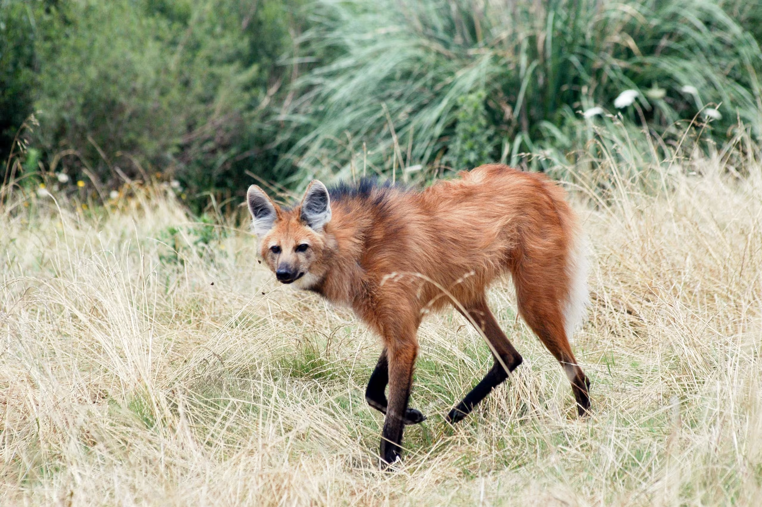
Cross the open grassland by vehicle in search of maned wolf, giant anteater, marsh deer, and pampas deer, the large mammals that make Barba Azul one of the best places in Bolivia for savanna wildlife.
Boat Trip on the Omi River
Explore the reserve's only year-round river by small boat, drifting past caiman, capybara, and water birds along the forested banks. The Omi is the lifeline that carries wildlife through the dry months.

Walking the Forest Islands
Follow trails onto the raised islands of palm and tropical forest that rise from the savanna, many of them shaped by pre-Columbian communities centuries ago. These islands are the richest wildlife habitat in the reserve.
Design Your Custom Trip
Tell us about your dream adventure. Our travel specialists respond within 24 hours with a personalised itinerary.
12,200 Hectares of Beni Savanna and Bolivia's Blue-throated Macaw Stronghold
A Closer Look at Barba Azul Nature Reserve

The Heart of the Beni Savanna
The Barba Azul Nature Reserve covers 12,200 hectares in the Llanos de Moxos, the vast seasonally flooded savanna that spreads across northern Bolivia’s Beni Department. For roughly eight months of the year much of the reserve lies under shallow water, then dries out into open grassland cut by the Omi River and studded with raised islands of palm and tropical forest. These forest islands, many of them built up over centuries by pre-Columbian communities, sit a few meters above the floodplain and hold the trees, fruit, and shelter that wildlife depends on once the waters recede. Five distinct habitats meet here: open savanna, treed cerrado, forest islands, gallery forest, and marsh wetland.
Asociación Armonía, the BirdLife International partner in Bolivia, established the reserve in 2008 and has expanded it through successive land purchases from an initial core to its present size. The reserve is the first protected area created specifically for the Blue-throated Macaw, a parrot found nowhere outside this corner of Bolivia. It is also Bolivia’s only site in the Western Hemisphere Shorebird Reserve Network, recognized for the migratory sandpipers that stop here on their journey between the Arctic and the pampas of Argentina. Today Barba Azul functions as both a wildlife reserve and a working biological station, drawing researchers, birders, and conservationists from around the world.
Saving the Blue-throated Macaw
The Blue-throated Macaw is one of the rarest parrots on earth, a large blue and yellow bird endemic to the Beni savanna and listed as Critically Endangered. Feared extinct in the wild until a population was confirmed in the early 1990s, fewer than 450 are thought to remain across three separate subpopulations in northern Bolivia. The species was driven to the edge by decades of capture for the pet trade and by the loss of the old palm trees it needs for nesting. Barba Azul protects the largest of the three groups, and the reserve has become the species’ most important refuge in the dry season.
Through the non-breeding months the macaws gather to roost in the reserve’s forest islands, and the counts have climbed steadily as habitat has recovered. In July 2022 a record 228 birds were seen flying to a single roost, more than half of the known wild population at the time. Armonía’s team supports the species across the wider landscape with artificial nest boxes, fire management, and research that has tracked where the birds breed beyond the reserve. Visitors in the dry season can watch flocks of thirty to seventy macaws stream across the savanna at first and last light, one of the great wildlife spectacles of South America.
Savanna Wildlife and Shorebirds
Barba Azul is far more than a single species. More than 340 bird species have been recorded across its grasslands, wetlands, and forest islands, including up to six macaw species, Greater Rhea, Jabiru, Southern Screamer, and a long list of savanna specialists prized by birders. The open country is some of the best in Bolivia for large mammals: maned wolf, giant anteater, marsh deer, and pampas deer are all seen regularly, and jaguar, puma, and ocelot move through the reserve. Black and yacaré caiman patrol the river channels, while capybara and black howler monkeys are common around the forest edges.
Each September the reserve fills with migratory shorebirds making the long flight between the Arctic and southern South America. As Bolivia’s only Western Hemisphere Shorebird Reserve Network site, Barba Azul is the country’s most important stopover for the Buff-breasted Sandpiper, with thousands recorded in peak years alongside Pectoral and Upland Sandpipers and American Golden-Plover. The reserve’s short-grass habitat, kept open in part by a carefully managed herd of cattle, gives these birds the feeding grounds they need. Days here are spent walking the forest island trails, watching macaw roosts at dusk, and exploring the Omi River by boat.
Explore More
Other Bolivia Destinations
Explore more destinations across Bolivia.
Tarija Wine Country
In the far south of Bolivia, near the Argentine border, the city of Tarija and the surrounding valleys form the...
ExploreNoel Kempff Mercado
Spread across 1,523,446 hectares of remote northeastern Bolivia along the Brazilian border, Noel Kempff Mercado is one of South America's...
ExploreKaa-Iya National Park
Larger than Belgium and home to one of the largest jaguar populations in South America, Kaa-Iya del Gran Chaco is...
ExploreEduardo Avaroa Andean Fauna National Reserve
On Bolivia's altiplano above 4,200 meters, in the country's far southwestern corner where it meets Chile and Argentina, lies one...
ExploreSanta Cruz de la Sierra
In Bolivia's tropical lowlands, where the Andes tumble into the Amazon, Santa Cruz opens doors to landscapes found nowhere else...
ExploreAmboro National Park
At the Elbow of the Andes, where the mountains bend westward toward Peru, Amboró National Park sits at one of...
ExploreSamaipata
Around 300 CE, peoples of the Mojocoyas culture, later associated with the Chané, began sculpting a 220-meter sandstone monolith with...
ExploreSucre
Founded in 1538 as Ciudad de la Plata by Spanish colonists profiting from nearby Potosí's silver mines, Sucre grew into...
ExplorePotosí
In 1545, an indigenous prospector named Diego Huallpa found silver on a mountain the Inca had long held sacred. Within...
ExploreMadidi National Park
Identified by Wildlife Conservation Society researchers as probably the most biodiverse protected area on Earth, Madidi spans nearly 19,000 square...
ExploreNorth Yungas Road
Carved into sheer cliffs in the 1930s, the North Yungas Road, El Camino de la Muerte, is estimated to have...
ExploreLake Titicaca
At 3,812 meters, Lake Titicaca stretches across the Andean altiplano like a shimmering inland sea, the highest navigable lake in...
ExploreSalar de Uyuni
At 3,656 meters on the Bolivian Altiplano lies the world's largest salt flat, a 10,582-square-kilometer expanse of crystalline white that...
ExploreLa Paz
Perched between 3,250 and 4,100 meters above sea level, La Paz defies gravity and expectations as the world's highest administrative...
Explore