


Travel to Amboro National Park
From Amazon Jungle to Andean Cloud Forest in Central Bolivia
Amboro National Park
From Amazon Jungle to Andean Cloud Forest in Central Bolivia

Ecovoyager Experiences
Amboro National Park Tours
Handcrafted expeditions into the remote corners of Amboro National Park — led by local experts, designed for the curious traveller.
Experience Amboro National Park, Your Way
Skip the standard itineraries. We design journeys around your interests, timeline, and curiosity with exclusive access you won't find on any platform.


Things to Do in Amboro National Park
Starting points for your perfect trip
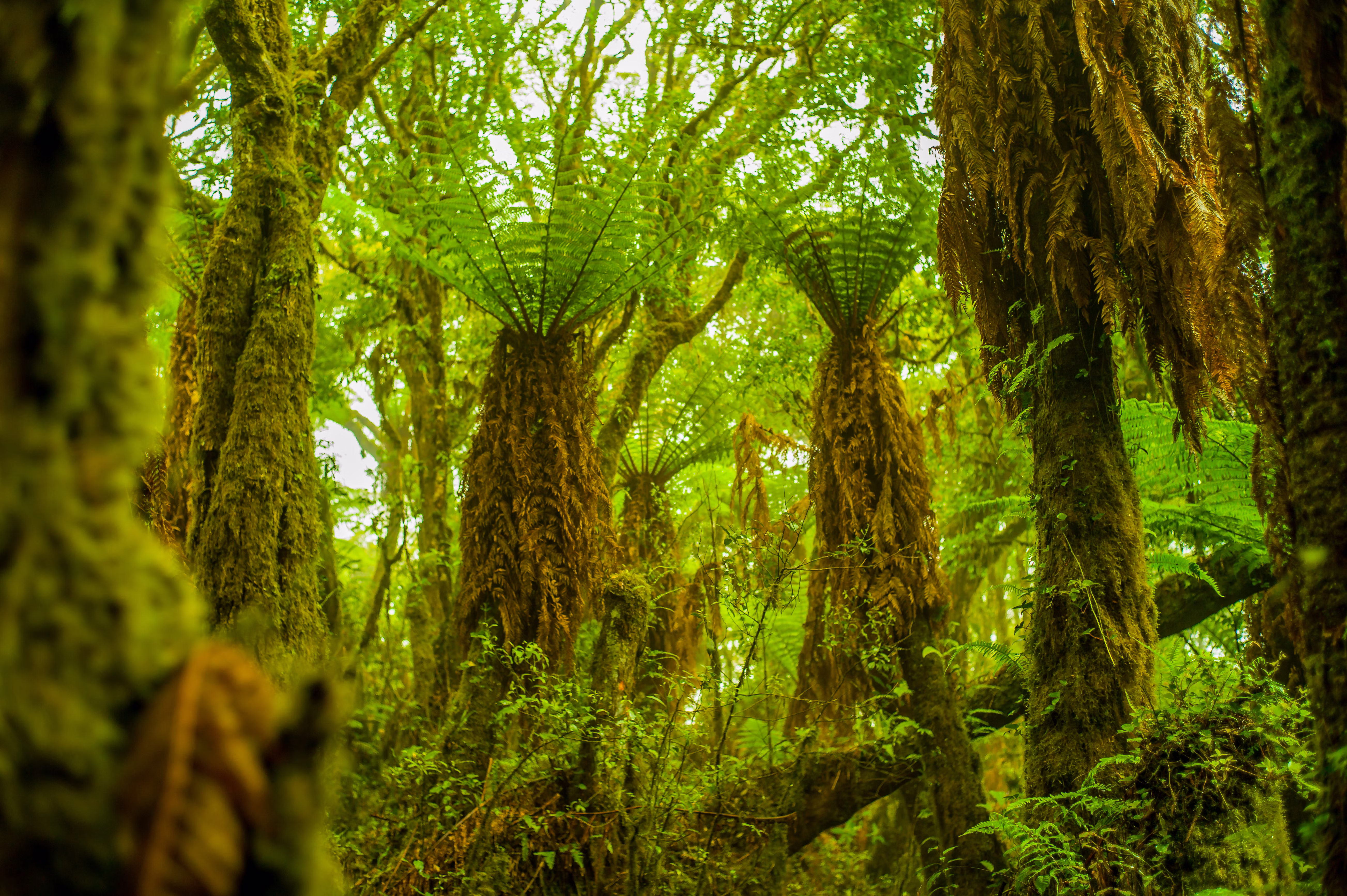
Prehistoric Giant Fern Trek
Walk through Amboró's cloud forest among giant tree ferns up to thirteen meters tall, part of an ancient lineage that dates back to the age of the dinosaurs.
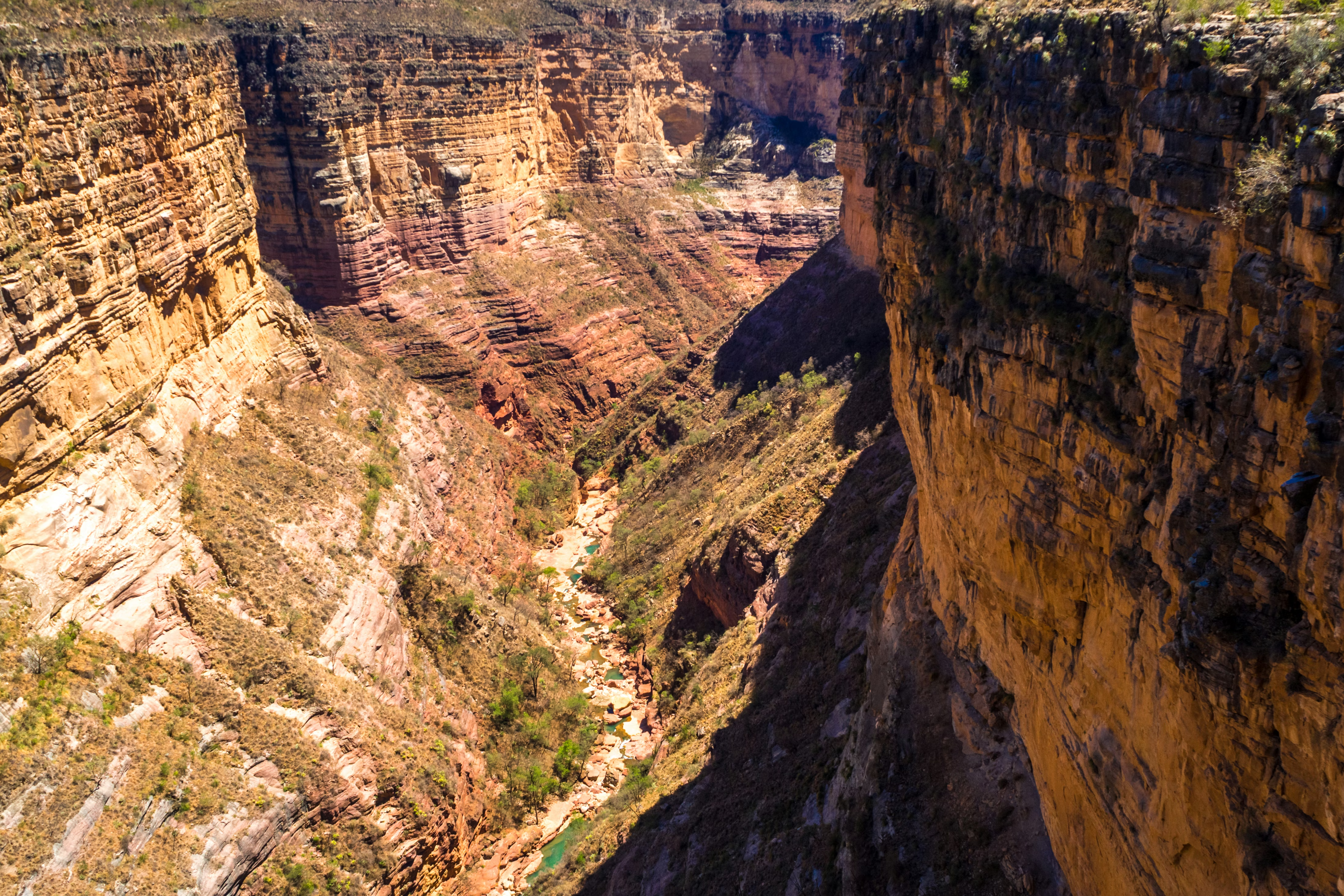
World-Class Birding
Search for some of South America's richest birdlife in the red sandstone valley of Los Volcanes. Watch Andean condors soar above the cliffs, look for the rare horned curassow, the park's Critically Endangered emblem.
Jungle Waterfall Trek
Trek into Amboró's northern lowland rainforest, crossing clear rivers and swimming in waterfall pools along the way. Camp beneath the jungle canopy, listening for howler monkeys and night sounds while local guides point out medicinal plants, animal tracks, and the birds of the Amazonian forest.
Andean Condor Dawn Watch
Set out before sunrise for Loma de los Cóndores, climbing through sub-Andean forest to a ridge viewpoint at around 2,600 meters. Wait as Andean condors, among the largest flying birds on Earth, lift off and glide just meters overhead on the morning thermals, with the Andean peaks falling away below.
Design Your Custom Trip
Tell us about your dream adventure. Our travel specialists respond within 24 hours with a personalised itinerary.

Stories from Amboro National Park
Where Three Worlds Collide
Amboró National Park occupies one of the most remarkable geographic positions in South America. It lies at the Elbow of the Andes, where the continent’s great mountain spine bends westward toward Peru. The strictly protected park covers 4,425 square kilometers, or 442,500 hectares, and together with its surrounding management area the protected complex reaches 637,600 hectares. Here three of the continent’s major biomes meet: the Amazon Basin, the Andean Yungas, and the Gran Chaco lowlands. Few places on Earth bring three such different worlds together, and the result is a mosaic of habitats that shifts from steaming tropical jungle to misty cloud forest to dry highland scrub within a single day’s trek.
The result is extraordinary biological richness. With nearly 3,000 documented plant species, more than the entire British Isles in an area many times smaller, Amboró ranks among the most botanically rich protected areas in South America. Its vegetation types read like an encyclopedia: lowland rainforest, cloud forest, palm forest, tree-fern groves, cactus scrub, tropical Yungas, montane scrubland, and open pampas. Because of the park’s rugged terrain and lack of roads, much of it has never been surveyed, and biologists are confident that species still await discovery in Amboró’s remotest valleys, where new records continue to be added.
From the Journal
Stories from Amboro National Park
Field notes, cultural encounters, and trail dispatches from our guides and travellers in Amboro National Park.

Explore More
Other Bolivia Destinations
Explore more destinations across Bolivia.
Barba Azul Nature Reserve
In the heart of Bolivia's Beni savanna, the Barba Azul Nature Reserve protects 12,200 hectares of seasonally flooded grassland, palm...
ExploreTarija Wine Country
In the far south of Bolivia, near the Argentine border, the city of Tarija and the surrounding valleys form the...
ExploreNoel Kempff Mercado
Spread across 1,523,446 hectares of remote northeastern Bolivia along the Brazilian border, Noel Kempff Mercado is one of South America's...
ExploreKaa-Iya National Park
Larger than Belgium and home to one of the largest jaguar populations in South America, Kaa-Iya del Gran Chaco is...
ExploreEduardo Avaroa Andean Fauna National Reserve
On Bolivia's altiplano above 4,200 meters, in the country's far southwestern corner where it meets Chile and Argentina, lies one...
ExploreSanta Cruz de la Sierra
In Bolivia's tropical lowlands, where the Andes tumble into the Amazon, Santa Cruz opens doors to landscapes found nowhere else...
ExploreSamaipata
Around 300 CE, peoples of the Mojocoyas culture, later associated with the Chané, began sculpting a 220-meter sandstone monolith with...
ExploreSucre
Founded in 1538 as Ciudad de la Plata by Spanish colonists profiting from nearby Potosí's silver mines, Sucre grew into...
ExplorePotosí
In 1545, an indigenous prospector named Diego Huallpa found silver on a mountain the Inca had long held sacred. Within...
ExploreMadidi National Park
Identified by Wildlife Conservation Society researchers as probably the most biodiverse protected area on Earth, Madidi spans nearly 19,000 square...
ExploreNorth Yungas Road
Carved into sheer cliffs in the 1930s, the North Yungas Road, El Camino de la Muerte, is estimated to have...
ExploreLake Titicaca
At 3,812 meters, Lake Titicaca stretches across the Andean altiplano like a shimmering inland sea, the highest navigable lake in...
ExploreSalar de Uyuni
At 3,656 meters on the Bolivian Altiplano lies the world's largest salt flat, a 10,582-square-kilometer expanse of crystalline white that...
ExploreLa Paz
Perched between 3,250 and 4,100 meters above sea level, La Paz defies gravity and expectations as the world's highest administrative...
Explore